IMAGES TAKEN NEAR TO
Kilwinning Road, KILMARNOCK, KA3 3BU
Introduction
This page details the photographs taken nearby to Kilwinning Road, KA3 3BU by members of the Geograph project.
The Geograph project started in 2005 with the aim of publishing, organising and preserving representative images for every square kilometre of Great Britain, Ireland and the Isle of Man.

There are currently over 7.5m images from over14,400 individuals and you can help contribute to the project by visiting https://www.geograph.org.uk
Image Map
Images are licensed for reuse under creativecommons.org/licenses/by-sa/2.0
Notes
- Clicking on the map will re-center to the selected point.
- The higher the marker number, the further away the image location is from the centre of the postcode.
Image Listing (36 Images Found)
Images are licensed for reuse under creativecommons.org/licenses/by-sa/2.0
Image
Details
Distance
1
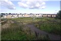
New houses, edge of Stewarton
An informal area next to a new development.
Image: © Richard Webb
Taken: 9 Sep 2017
0.09 miles
2

Lainshaw Farm Eggs
A derelict building which appears at one time to have been an egg packing facility.
Image: © James Allan
Taken: 25 Dec 2009
0.17 miles
3
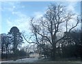
Bare limbs
Trees at the entrance to Lainshaw Estate.
Image: © James Allan
Taken: 25 Dec 2010
0.19 miles
4

Lainshaw Mains Farm
Viewed from near Lainshaw house.
Image: © James Allan
Taken: 25 Dec 2009
0.19 miles
5

Entrance gatehouse to Lainshaw estate
There is an older gatehouse farther east, now surrounded by council houses.
Image: © James Allan
Taken: 25 Dec 2009
0.20 miles
6
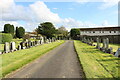
Stewarton Cemetery
Accessed from the B778 Dalry Road.
Image: © Billy McCrorie
Taken: 29 Sep 2020
0.20 miles
7

Stewarton Cemetery
Accessed from the B778 Dalry Road.
Image: © Billy McCrorie
Taken: 29 Sep 2020
0.21 miles
8
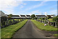
Stewarton Cemetery
Accessed from the B778 Dalry Road.
Image: © Billy McCrorie
Taken: 29 Sep 2020
0.21 miles
9
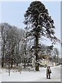
Midday Christmas 2009
Chilly Monkey puzzle in Lainshaw estate.
Image: © James Allan
Taken: 25 Dec 2009
0.21 miles
10
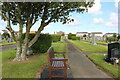
Stewarton Cemetery
Accessed from the B778 Dalry Road.
Image: © Billy McCrorie
Taken: 29 Sep 2020
0.21 miles