IMAGES TAKEN NEAR TO
Altonhead Terrace, KILMARNOCK, KA3 2PA
Introduction
This page details the photographs taken nearby to Altonhead Terrace, KA3 2PA by members of the Geograph project.
The Geograph project started in 2005 with the aim of publishing, organising and preserving representative images for every square kilometre of Great Britain, Ireland and the Isle of Man.

There are currently over 7.5m images from over14,400 individuals and you can help contribute to the project by visiting https://www.geograph.org.uk
Image Map (Loading...)


Getting Data...Please wait
Leaflet Map data © OpenStreetMap
Images are licensed for reuse under creativecommons.org/licenses/by-sa/2.0
Notes
- Clicking on the map will re-center to the selected point.
- The higher the marker number, the further away the image location is from the centre of the postcode.
Image Listing (8 Images Found)
Images are licensed for reuse under creativecommons.org/licenses/by-sa/2.0
Image
Details
Distance
1
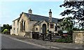
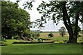
Converted school in Cunninghamhead
The hamlet was previously Cross Roads.
Image: © Alan Reid
Taken: 13 Jul 2021
0.04 miles
2
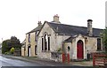
Cunninghamhead
What appears to be a converted church or school near the crossroads.
Image: © Thomas Nugent
Taken: 25 May 2006
0.05 miles
4
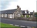
Dykehead Farm
At Cunninghamhead on the B769.
Image: © Thomas Nugent
Taken: 25 May 2006
0.12 miles
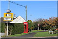
5
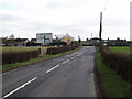
Road Sign
On the outskirts of Cunninghamhead on the B769
Image: © Gordon Dowie
Taken: 14 Apr 2010
0.14 miles
7
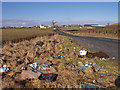
Rubbish at Layby
At roadside near Cunninghamhead.
Image: © wfmillar
Taken: 17 Feb 2010
0.21 miles
8
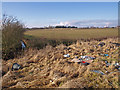
Layby Rubbish
Clapingstone Burn beside hedge.
Image: © wfmillar
Taken: 17 Feb 2010
0.21 miles