IMAGES TAKEN NEAR TO
Kilmaurs, KILMARNOCK, KA3 2NE
Introduction
This page details the photographs taken nearby to KA3 2NE by members of the Geograph project.
The Geograph project started in 2005 with the aim of publishing, organising and preserving representative images for every square kilometre of Great Britain, Ireland and the Isle of Man.

There are currently over 7.5m images from over14,400 individuals and you can help contribute to the project by visiting https://www.geograph.org.uk
Image Map
Images are licensed for reuse under creativecommons.org/licenses/by-sa/2.0
Notes
- Clicking on the map will re-center to the selected point.
- The higher the marker number, the further away the image location is from the centre of the postcode.
Image Listing (9 Images Found)
Images are licensed for reuse under creativecommons.org/licenses/by-sa/2.0
Image
Details
Distance
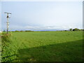
1

Communications mast, near Kilmaurs
Sun has not managed to melt the frosty tracks in the field.
Image: © wfmillar
Taken: 17 Feb 2010
0.06 miles
3
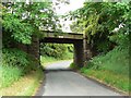
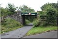
Standalane bridge
Carrying the Glasgow to Kilmarnock main line across a minor road north of Kilmaurs.
Image: © James Allan
Taken: 24 Jun 2010
0.09 miles
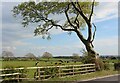
4
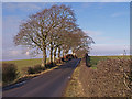
Minor Road, Kilmaurs
Beech trees line on side of road near Kilmaurs.
Image: © wfmillar
Taken: 17 Feb 2010
0.13 miles
6
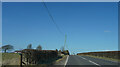
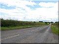
The A735
Now heading along the A735 towards Stewarton which is another village in Ayrshire.
Image: © Malcolm Neal
Taken: 20 Mar 2022
0.21 miles
8
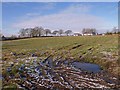
The Fields Cottage
Muddy entrance to a field. Brackenhill Cottage on the left.
Image: © wfmillar
Taken: 17 Feb 2010
0.22 miles