IMAGES TAKEN NEAR TO
Standalane, KILMARNOCK, KA3 2NB
Introduction
This page details the photographs taken nearby to Standalane, KA3 2NB by members of the Geograph project.
The Geograph project started in 2005 with the aim of publishing, organising and preserving representative images for every square kilometre of Great Britain, Ireland and the Isle of Man.

There are currently over 7.5m images from over14,400 individuals and you can help contribute to the project by visiting https://www.geograph.org.uk
Image Map
Images are licensed for reuse under creativecommons.org/licenses/by-sa/2.0
Notes
- Clicking on the map will re-center to the selected point.
- The higher the marker number, the further away the image location is from the centre of the postcode.
Image Listing (19 Images Found)
Images are licensed for reuse under creativecommons.org/licenses/by-sa/2.0
Image
Details
Distance
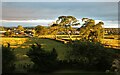
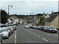
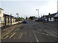
2
Kilmaurs Village
Looking south to the centre of the Village
Image: © Iain Marshall
Taken: 14 Jun 2006
0.13 miles
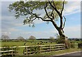
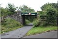
6
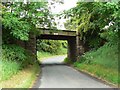
Standalane bridge
Carrying the Glasgow to Kilmarnock main line across a minor road north of Kilmaurs.
Image: © James Allan
Taken: 24 Jun 2010
0.21 miles
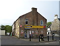
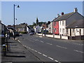
9
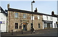
The 30 Main Bar & Restaurant, Kilmaurs
On Main Street.
Image: © JThomas
Taken: 23 May 2021
0.23 miles
10
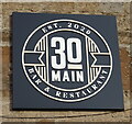
Sign on the 30 Main Bar & Restaurant, Kilmaurs
Image: © JThomas
Taken: 23 May 2021
0.23 miles