IMAGES TAKEN NEAR TO
KILMARNOCK, KA3 2LN
Introduction
This page details the photographs taken nearby to KA3 2LN by members of the Geograph project.
The Geograph project started in 2005 with the aim of publishing, organising and preserving representative images for every square kilometre of Great Britain, Ireland and the Isle of Man.

There are currently over 7.5m images from over14,400 individuals and you can help contribute to the project by visiting https://www.geograph.org.uk
Image Map
Images are licensed for reuse under creativecommons.org/licenses/by-sa/2.0
Notes
- Clicking on the map will re-center to the selected point.
- The higher the marker number, the further away the image location is from the centre of the postcode.
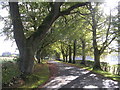
Image Listing (6 Images Found)
Images are licensed for reuse under creativecommons.org/licenses/by-sa/2.0
Image
Details
Distance
3
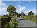
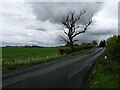
Straight road, Tannahill
A yellow road north of Kilmarnock.
Image: © Richard Webb
Taken: 25 Sep 2015
0.18 miles
4
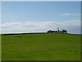
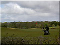
Clump of trees, Tannahill
Farmland north of Kilmarnock.
Image: © Richard Webb
Taken: 25 Sep 2015
0.19 miles
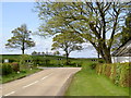
5
Minor road near Kilmarnock
This road runs between the B751 Kilmaurs-Fenwick road and the B7038 that runs from Fenwick into Kilmarnock. The picture shows the first tens of metres, with its northern end (Image) just out of sight round the slight bend.
Image: © Alec MacKinnon
Taken: 25 Apr 2022
0.20 miles