IMAGES TAKEN NEAR TO
Arness Court, KILMARNOCK, KA3 2DR
Introduction
This page details the photographs taken nearby to Arness Court, KA3 2DR by members of the Geograph project.
The Geograph project started in 2005 with the aim of publishing, organising and preserving representative images for every square kilometre of Great Britain, Ireland and the Isle of Man.

There are currently over 7.5m images from over14,400 individuals and you can help contribute to the project by visiting https://www.geograph.org.uk
Image Map (Loading...)


Getting Data...Please wait
Leaflet Map data © OpenStreetMap
Images are licensed for reuse under creativecommons.org/licenses/by-sa/2.0
Notes
- Clicking on the map will re-center to the selected point.
- The higher the marker number, the further away the image location is from the centre of the postcode.
Image Listing (13 Images Found)
Images are licensed for reuse under creativecommons.org/licenses/by-sa/2.0
Image
Details
Distance
1
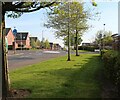
Suburban housing, John Walker Drive, Kilmarnock
Image: © Alan Reid
Taken: 29 Apr 2022
0.15 miles
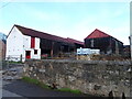
4
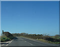
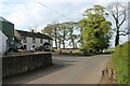
The A735
Moving away from Kilmarnock out into the countryside along the A735 otherwise known as Kilmaurs Road.
Image: © Malcolm Neal
Taken: 20 Mar 2022
0.19 miles
5
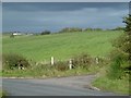
Off the Kilmaurs Road
The edge of Kilmarnock with a yellow road heading north towards Stewarton. The road on the right serves a gas installation.
Image: © Richard Webb
Taken: 25 Sep 2015
0.20 miles
6
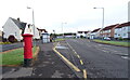
Kilmaurs Road (A735), Kilmarnock
Showing position of Postbox No. KA3 120.
See Image] for postbox.
Image: © JThomas
Taken: 24 May 2021
0.22 miles
7
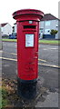
George VI postbox on Kilmaurs Road, Kilmarnock
Image: © JThomas
Taken: 24 May 2021
0.22 miles
9

Minor road, Altonhill
Towards Knockentiber.
Image: © JThomas
Taken: 24 May 2021
0.22 miles