IMAGES TAKEN NEAR TO
Edradour Place, KILMARNOCK, KA3 1US
Introduction
This page details the photographs taken nearby to Edradour Place, KA3 1US by members of the Geograph project.
The Geograph project started in 2005 with the aim of publishing, organising and preserving representative images for every square kilometre of Great Britain, Ireland and the Isle of Man.

There are currently over 7.5m images from over14,400 individuals and you can help contribute to the project by visiting https://www.geograph.org.uk
Image Map
Images are licensed for reuse under creativecommons.org/licenses/by-sa/2.0
Notes
- Clicking on the map will re-center to the selected point.
- The higher the marker number, the further away the image location is from the centre of the postcode.
Image Listing (2 Images Found)
Images are licensed for reuse under creativecommons.org/licenses/by-sa/2.0
Image
Details
Distance
1
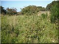
Glasgow, Paisley, Kilmarnock and Ayr Railway
The railway between Kilmarnock and Dalry, closed in 1966. My map, dated 2002 shows that this bit still had rails, but now it is overgrown, save for the cycle path to Irvine.
Image: © Richard Webb
Taken: 9 Sep 2009
0.21 miles
2
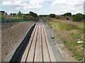
Passing Loop
Loop formed recently to allow engines on goods trains to change ends. This loop has been built on the route of the Kilmarnock to Crosshouse rail line which was closed and has been turned into a cycle route. The path continues in the distance from the access ramp on the left of picture.
Image: © Gordon Dowie
Taken: 12 Jul 2010
0.24 miles