IMAGES TAKEN NEAR TO
Rothesay Place, KILMARNOCK, KA3 1SZ
Introduction
This page details the photographs taken nearby to Rothesay Place, KA3 1SZ by members of the Geograph project.
The Geograph project started in 2005 with the aim of publishing, organising and preserving representative images for every square kilometre of Great Britain, Ireland and the Isle of Man.

There are currently over 7.5m images from over14,400 individuals and you can help contribute to the project by visiting https://www.geograph.org.uk
Image Map
Images are licensed for reuse under creativecommons.org/licenses/by-sa/2.0
Notes
- Clicking on the map will re-center to the selected point.
- The higher the marker number, the further away the image location is from the centre of the postcode.
Image Listing (6 Images Found)
Images are licensed for reuse under creativecommons.org/licenses/by-sa/2.0
Image
Details
Distance
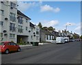
1
Western Road
Semi detached houses on Western Road.
Image: © Malcolm Neal
Taken: 20 Mar 2022
0.16 miles
2
On Beansburn
The sign for Dean Castle Country Park is just up ahead.
Image: © Malcolm Neal
Taken: 20 Mar 2022
0.17 miles
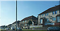
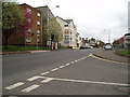
3
Dean Street
The white buildings are newly built flats on the former site of Bomphrey's garage.
Image: © Richard Webb
Taken: 9 Sep 2009
0.20 miles
4
Dean Street
The white building of flats is on the site of a garage.
Image: © Richard Webb
Taken: 25 Sep 2015
0.21 miles
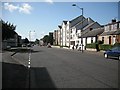
5
Dean Street Kilmarnock
Pictured from the junction with Gillsburn Gardens.
Image: © Gordon Dowie
Taken: 4 May 2010
0.21 miles
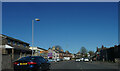
6
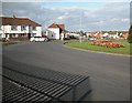
Roundabout on the Kilmaurs Road
Junction on the western side of Kilmarnock.
Image: © Richard Webb
Taken: 9 Sep 2009
0.23 miles