IMAGES TAKEN NEAR TO
Turner Place, KILMARNOCK, KA3 1RS
Introduction
This page details the photographs taken nearby to Turner Place, KA3 1RS by members of the Geograph project.
The Geograph project started in 2005 with the aim of publishing, organising and preserving representative images for every square kilometre of Great Britain, Ireland and the Isle of Man.

There are currently over 7.5m images from over14,400 individuals and you can help contribute to the project by visiting https://www.geograph.org.uk
Image Map
Images are licensed for reuse under creativecommons.org/licenses/by-sa/2.0
Notes
- Clicking on the map will re-center to the selected point.
- The higher the marker number, the further away the image location is from the centre of the postcode.
Image Listing (30 Images Found)
Images are licensed for reuse under creativecommons.org/licenses/by-sa/2.0
Image
Details
Distance
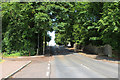
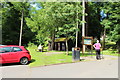
1
On Beansburn
The sign for Dean Castle Country Park is just up ahead.
Image: © Malcolm Neal
Taken: 20 Mar 2022
0.06 miles
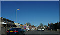
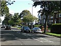
2
Glasgow Road
Looking downhill towards the town centre.
Image: © Richard Webb
Taken: 9 Sep 2009
0.12 miles

7
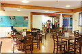
The Tearoom at Dean Castle Country Park
Image: © Billy McCrorie
Taken: 7 Jul 2016
0.16 miles
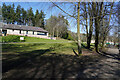
8
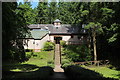
Tearoom & Visitor Centre
At Dean Castle Country Park.
Image: © Billy McCrorie
Taken: 7 Jul 2016
0.16 miles
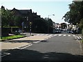
9
Glasgow Road
A residential street and major route out of Kilmarnock.
Image: © Richard Webb
Taken: 9 Sep 2009
0.17 miles
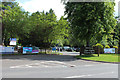
10
Looking towards the cafe
According to our friends this is a relatively new cafe.
Image: © Malcolm Neal
Taken: 20 Mar 2022
0.17 miles