IMAGES TAKEN NEAR TO
Altonhill Avenue, KILMARNOCK, KA3 1PJ
Introduction
This page details the photographs taken nearby to Altonhill Avenue, KA3 1PJ by members of the Geograph project.
The Geograph project started in 2005 with the aim of publishing, organising and preserving representative images for every square kilometre of Great Britain, Ireland and the Isle of Man.

There are currently over 7.5m images from over14,400 individuals and you can help contribute to the project by visiting https://www.geograph.org.uk
Image Map
Images are licensed for reuse under creativecommons.org/licenses/by-sa/2.0
Notes
- Clicking on the map will re-center to the selected point.
- The higher the marker number, the further away the image location is from the centre of the postcode.
Image Listing (12 Images Found)
Images are licensed for reuse under creativecommons.org/licenses/by-sa/2.0
Image
Details
Distance
1

Kilmaurs Road, Kilmarnock
Leaving town on the A735. The schools were emptying with East Ayrshire not having a holiday today unlike Glasgow and East Renfrewshire.
Image: © Richard Webb
Taken: 25 Sep 2015
0.14 miles
2

Hillhead Primary School
This school sits on the Kilmaurs road A735 heading NNW out of the Eastern edge of Kilmarnock
Image: © Ian Rainey
Taken: 23 May 2006
0.14 miles


6
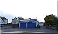
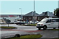
Knockinlaw Area of Kilmarnock
Housing estate in the north of Kilmarnock.
Image: © wfmillar
Taken: 9 Nov 2011
0.16 miles
7
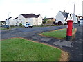
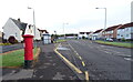
Kilmaurs Road, Kilmarnock
Showing position of Postbox No. KA3 120.
See Image] for postbox.
Image: © JThomas
Taken: 24 May 2021
0.19 miles
8
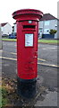
George VI postbox on Kilmaurs Road, Kilmarnock
Image: © JThomas
Taken: 24 May 2021
0.19 miles
9
Kilmaurs Road (A735), Kilmarnock
Showing position of Postbox No. KA3 120.
See Image] for postbox.
Image: © JThomas
Taken: 24 May 2021
0.19 miles
10
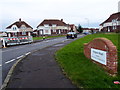
Kilmaurs Road Roundabout
Taken in 2002 from Western Road showing the top part of Hill Street.
The low-rise property on the centre left is the former Hillbank Nursery.
With the passage of time many other properties near this roundabout have either been demolished or modernised but save for the Johnnie Walker building, on the left skyline, this particular view has remained relatively unchanged for the last 50 years.
Image: © Tom Morrison
Taken: 26 Apr 2002
0.24 miles