IMAGES TAKEN NEAR TO
Bankhouse Crescent, LARGS, KA30 9PH
Introduction
This page details the photographs taken nearby to Bankhouse Crescent, KA30 9PH by members of the Geograph project.
The Geograph project started in 2005 with the aim of publishing, organising and preserving representative images for every square kilometre of Great Britain, Ireland and the Isle of Man.

There are currently over 7.5m images from over14,400 individuals and you can help contribute to the project by visiting https://www.geograph.org.uk
Image Map
Images are licensed for reuse under creativecommons.org/licenses/by-sa/2.0
Notes
- Clicking on the map will re-center to the selected point.
- The higher the marker number, the further away the image location is from the centre of the postcode.
Image Listing (105 Images Found)
Images are licensed for reuse under creativecommons.org/licenses/by-sa/2.0
Image
Details
Distance
1
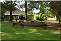
Douglas Park: The Burns Garden
The Robert Burns Memorial Garden, which is located within Douglas Park in Largs, was designed by Robert McKay, and was officially opened on the 27th of June, 1978.
For context, see Image; the building with the brick-red roof in that picture is the same one as appears in the present photograph, viewed from the other side. By the end of 2017, that building was gone: Image
Image: © Lairich Rig
Taken: 3 Sep 2012
0.07 miles
2
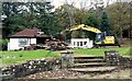
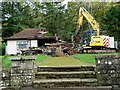
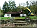
Demolition of Douglas Park Shelter - Largs
The demolition of Douglas Park shelter and toilets took place on Monday 30th October,2017.
Image: © Raibeart MacAoidh
Taken: 30 Oct 2017
0.07 miles
3
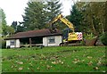
Demolition of Douglas Park Shelter - Largs
The demolition of Douglas Park shelter and toilets took place on Monday 30th October,2017.
Image: © Raibeart MacAoidh
Taken: 30 Oct 2017
0.07 miles
4
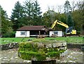
Demolition of Douglas Park Shelter - Largs
The demolition of Douglas Park shelter and toilets took place on Monday 30th October,2017.
Image: © Raibeart MacAoidh
Taken: 30 Oct 2017
0.07 miles
5
Demolition of Douglas Park Shelter - Largs
The demolition of Douglas Park shelter and toilets took place on Monday 30th October,2017.
Image: © Raibeart MacAoidh
Taken: 30 Oct 2017
0.07 miles
6
Demolition of Douglas Park Shelter - Largs
The demolition of Douglas Park shelter and toilets took place on Monday 30th October,2017.
Image: © Raibeart MacAoidh
Taken: 30 Oct 2017
0.07 miles
7
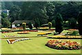
Douglas Park Gardens
Douglas Park Gardens - Summer Bedding 1991.
Incidentally I was gardener at Douglas Park for 44 years from 1968.
Image: © Raibeart MacAoidh
Taken: 12 Aug 1991
0.07 miles
8
Douglas Park Gardens
Douglas Park Gardens - Summer Bedding 1991.
Incidentally I was gardener at Douglas Park for 44 years from 1968.
Image: © Raibeart MacAoidh
Taken: 12 Aug 1991
0.08 miles
9
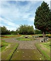
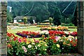
Douglas Park: the Victorian Garden
This is the centre of the Victorian Garden; this part of Douglas Park lies just to the east of the bowling green (Image).
See Image for another view of the park, and for further information.
Image: © Lairich Rig
Taken: 3 Sep 2012
0.08 miles
10
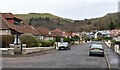
Scott Street, Largs, North Ayrshire
The view looking up Scott Street, with Whinhill Avenue on the left.
Image: © Mark S
Taken: 27 Nov 2020
0.08 miles