IMAGES TAKEN NEAR TO
Halkshill Drive, LARGS, KA30 9PD
Introduction
This page details the photographs taken nearby to Halkshill Drive, KA30 9PD by members of the Geograph project.
The Geograph project started in 2005 with the aim of publishing, organising and preserving representative images for every square kilometre of Great Britain, Ireland and the Isle of Man.

There are currently over 7.5m images from over14,400 individuals and you can help contribute to the project by visiting https://www.geograph.org.uk
Image Map
Images are licensed for reuse under creativecommons.org/licenses/by-sa/2.0
Notes
- Clicking on the map will re-center to the selected point.
- The higher the marker number, the further away the image location is from the centre of the postcode.
Image Listing (88 Images Found)
Images are licensed for reuse under creativecommons.org/licenses/by-sa/2.0
Image
Details
Distance
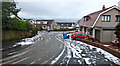
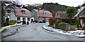
1

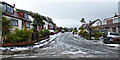
Halkshill Drive
At the top of Scott Drive.
Image: © Thomas Nugent
Taken: 30 Dec 2017
0.03 miles
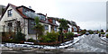
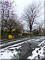
2
Scott Drive
The highest point in the road.
Image: © Thomas Nugent
Taken: 30 Dec 2017
0.03 miles
3
Scott Drive
Halkshill Drive is on the left.
Image: © Thomas Nugent
Taken: 30 Dec 2017
0.03 miles
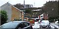
4
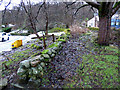
Old track off Stakehill
Remains of an old farm track which climbed up Castle Hill from Gogo Mill. Stakehill is on the left, Halkshill Drive on the right.
Image: © Thomas Nugent
Taken: 30 Dec 2017
0.03 miles
5
Scott Drive
The high point of the road.
Image: © Thomas Nugent
Taken: 30 Dec 2017
0.04 miles
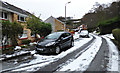
6
Halkshill Drive
Looking down the hill towards Scott Drive.
Image: © Thomas Nugent
Taken: 30 Dec 2017
0.04 miles
7
Stakehill
Halkshill Drive is beyond the wall.
Image: © Thomas Nugent
Taken: 30 Dec 2017
0.04 miles
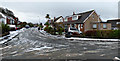
10
Scott Drive
Looking up the hill from Gogoside Road.
Image: © Thomas Nugent
Taken: 30 Dec 2017
0.07 miles