IMAGES TAKEN NEAR TO
Moorburn Road, LARGS, KA30 9JA
Introduction
This page details the photographs taken nearby to Moorburn Road, KA30 9JA by members of the Geograph project.
The Geograph project started in 2005 with the aim of publishing, organising and preserving representative images for every square kilometre of Great Britain, Ireland and the Isle of Man.

There are currently over 7.5m images from over14,400 individuals and you can help contribute to the project by visiting https://www.geograph.org.uk
Image Map
Images are licensed for reuse under creativecommons.org/licenses/by-sa/2.0
Notes
- Clicking on the map will re-center to the selected point.
- The higher the marker number, the further away the image location is from the centre of the postcode.
Image Listing (149 Images Found)
Images are licensed for reuse under creativecommons.org/licenses/by-sa/2.0
Image
Details
Distance
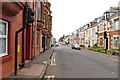
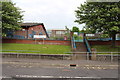
1
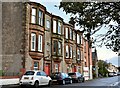
Moorburn Road, Largs, North Ayrshire
Tenements on Moorburn Road.
Image: © Mark S
Taken: 14 Oct 2023
0.00 miles
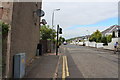
3
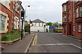
Nelson Street
Approaching junction with Moorburn Road.
Image: © Billy McCrorie
Taken: 3 Jun 2013
0.02 miles
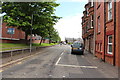
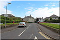
4
Nelson Street, Largs, North Ayrshire
Looking all the way down Nelson Street.
Image: © Mark S
Taken: 14 Oct 2023
0.02 miles
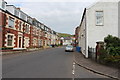
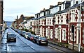
10
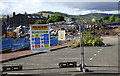
Site of Kelburn Primary School
The school building has been recently demolished. The school moved to a new shared campus nearby in early 2018.
Image: © Thomas Nugent
Taken: 16 Jun 2018
0.06 miles