IMAGES TAKEN NEAR TO
Bellesdale Avenue, LARGS, KA30 9EF
Introduction
This page details the photographs taken nearby to Bellesdale Avenue, KA30 9EF by members of the Geograph project.
The Geograph project started in 2005 with the aim of publishing, organising and preserving representative images for every square kilometre of Great Britain, Ireland and the Isle of Man.

There are currently over 7.5m images from over14,400 individuals and you can help contribute to the project by visiting https://www.geograph.org.uk
Image Map
Images are licensed for reuse under creativecommons.org/licenses/by-sa/2.0
Notes
- Clicking on the map will re-center to the selected point.
- The higher the marker number, the further away the image location is from the centre of the postcode.
Image Listing (81 Images Found)
Images are licensed for reuse under creativecommons.org/licenses/by-sa/2.0
Image
Details
Distance
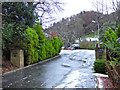
1
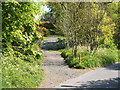
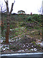
Footpath to Greeto Bridge
This is the point at which a footpath branches off from Bellesdale Avenue; it leads uphill, with Gogo Glen below and to the south; the footpath leads to Greeto Bridge, and beyond.
For a view from just past the gate that can be seen a short distance ahead, see Image
Image: © Lairich Rig
Taken: 13 May 2005
0.04 miles
2
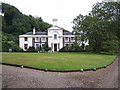
Halkshill House
North Ayrshire Council Headquarters
Image: © william craig
Taken: 26 Aug 2005
0.04 miles
3
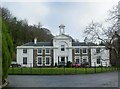
Halkshill House
Halkshill estate was purchased from Brisbane estate trustees in 1815 by John Scott, shipbuilder, Greenock.
Circa 1815. In the style of David Hamilton. 2-storey 7-bay house with classical detail. Category B-listed.
Image: © Raibeart MacAoidh
Taken: 29 Jan 2017
0.04 miles
4
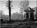
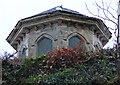
Halkshill Summerhouse
Halkshill Summerhouse stands above Halkshill House at Bellesdale.
Halkshill House was built in the early 1800's for John Scott of Scott's Shipbuilders of Greenock.
Image: © Raibeart MacAoidh
Taken: 6 Nov 2016
0.05 miles
5
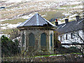
Halkshill House summerhouse
Perched on the top of a hill at the edge of a housing estate. In need of some repair. Category B Listed http://portal.historicenvironment.scot/designation/LB37173 . Viewed from Waterside Street.
Image: © Thomas Nugent
Taken: 30 Dec 2017
0.05 miles
6
Halkshill House summerhouse
Perched on the top of a hill at the edge of a housing estate. In need of some repair. Category B Listed http://portal.historicenvironment.scot/designation/LB37173 . Viewed from Waterside Street.
Image: © Thomas Nugent
Taken: 30 Dec 2017
0.05 miles
7
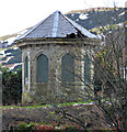
Halkshill House summerhouse
Perched on the top of a hill at the edge of a housing estate. In need of some repair. Category B Listed http://portal.historicenvironment.scot/designation/LB37173 . Viewed from Gogoside Road.
Image: © Thomas Nugent
Taken: 30 Dec 2017
0.05 miles
8
Halkshill House summerhouse
Perched on the top of a hill at the edge of a housing estate. In need of some repair. Category B Listed http://portal.historicenvironment.scot/designation/LB37173 . Viewed from Gogoside Road.
Image: © Thomas Nugent
Taken: 30 Dec 2017
0.05 miles
9
Waterside Street
At the entrance to Halkshill.
Image: © Thomas Nugent
Taken: 30 Dec 2017
0.06 miles
10
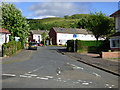
Flatt Road
Leads to Bellesdale Avenue.
Image: © Thomas Nugent
Taken: 16 Jun 2018
0.06 miles