IMAGES TAKEN NEAR TO
Flatt Road, LARGS, KA30 9EA
Introduction
This page details the photographs taken nearby to Flatt Road, KA30 9EA by members of the Geograph project.
The Geograph project started in 2005 with the aim of publishing, organising and preserving representative images for every square kilometre of Great Britain, Ireland and the Isle of Man.

There are currently over 7.5m images from over14,400 individuals and you can help contribute to the project by visiting https://www.geograph.org.uk
Image Map
Images are licensed for reuse under creativecommons.org/licenses/by-sa/2.0
Notes
- Clicking on the map will re-center to the selected point.
- The higher the marker number, the further away the image location is from the centre of the postcode.
Image Listing (139 Images Found)
Images are licensed for reuse under creativecommons.org/licenses/by-sa/2.0
Image
Details
Distance
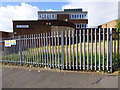
1
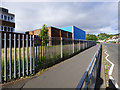
Former Largs Academy
Viewed from Flatt Road.
Image: © Thomas Nugent
Taken: 16 Jun 2018
0.03 miles
2
Former Largs Academy
Viewed from Flatt Road.
Image: © Thomas Nugent
Taken: 16 Jun 2018
0.03 miles
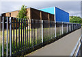
3
Workers' compound
A temporary compound on Flatt Road at the former Largs Academy site.
Image: © Thomas Nugent
Taken: 16 Jun 2018
0.03 miles
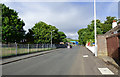
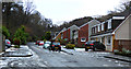
4
Flatt Road
Near the top of the hill, opposite the former Largs Academy site.
Image: © Thomas Nugent
Taken: 16 Jun 2018
0.04 miles
5
Former Largs Academy
Viewed from Flatt Road.
Image: © Thomas Nugent
Taken: 16 Jun 2018
0.05 miles
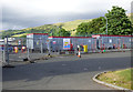
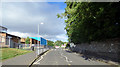
6
Flatt Road
The former Largs Academy site is on the left.
Image: © Thomas Nugent
Taken: 16 Jun 2018
0.05 miles
7
Flatt Road
The former Largs Academy is on the left.
Image: © Thomas Nugent
Taken: 16 Jun 2018
0.05 miles
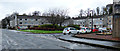
8
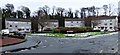
Silverdale Gardens
Off Waterside Street.
Image: © Thomas Nugent
Taken: 30 Dec 2017
0.06 miles
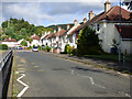
9
Waterside Street
Houses on the south side of the street, approaching Halkshill.
Image: © Thomas Nugent
Taken: 30 Dec 2017
0.07 miles
10
Silverdale Gardens
Off Waterside Street.
Image: © Thomas Nugent
Taken: 30 Dec 2017
0.07 miles