IMAGES TAKEN NEAR TO
Rankin Drive, LARGS, KA30 9DA
Introduction
This page details the photographs taken nearby to Rankin Drive, KA30 9DA by members of the Geograph project.
The Geograph project started in 2005 with the aim of publishing, organising and preserving representative images for every square kilometre of Great Britain, Ireland and the Isle of Man.

There are currently over 7.5m images from over14,400 individuals and you can help contribute to the project by visiting https://www.geograph.org.uk
Image Map
Images are licensed for reuse under creativecommons.org/licenses/by-sa/2.0
Notes
- Clicking on the map will re-center to the selected point.
- The higher the marker number, the further away the image location is from the centre of the postcode.
Image Listing (17 Images Found)
Images are licensed for reuse under creativecommons.org/licenses/by-sa/2.0
Image
Details
Distance
1
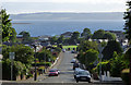
Burnside Road
Looking down the road to the Firth of Clyde from the entrance to Inverclyde National Sports Training Centre. The Isle of Bute is in the background.
Image: © Thomas Nugent
Taken: 16 Jun 2018
0.06 miles
2
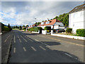
Burnside Way
At the top of Burnside Road.
Image: © Thomas Nugent
Taken: 16 Jun 2018
0.13 miles
3
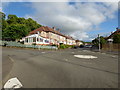
Alexander Avenue
The mini roundabout at the junction of Alexander Avenue, Burnside Road, Burnside Way and the entrance to Inverclyde sports centre.
Image: © Thomas Nugent
Taken: 16 Jun 2018
0.15 miles
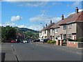
4
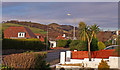
Burnside Way, Largs
The Knock is the hill in the distance. Largs hosts many Palm Trees and they seem to flourish.
Image: © wfmillar
Taken: 24 Nov 2010
0.15 miles
5
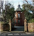
Fernes Villa and Gatepiers
Later 19th century. 2-storey 3-bay villa.
Category C(S) listed.
Image: © Raibeart MacAoidh
Taken: 1 Feb 2017
0.17 miles
6
Inverclyde National Sports Training Centre
The main entrance, off Burnside Road/Alexander Avenue.
Image: © Thomas Nugent
Taken: 16 Jun 2018
0.17 miles
7
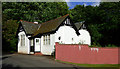
Inverclyde National Sports Training Centre
A gate house at the main entrance to the centre.
Image: © Thomas Nugent
Taken: 16 Jun 2018
0.18 miles
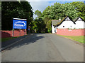
8
Alexander Avenue, Largs
Looking roughly north from the junction with Glenacre Drive.
Image: © Stephen Sweeney
Taken: 11 Jun 2014
0.19 miles
9
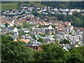
Largs from Netherhall
The northern suburbs of the town, viewed from the road to Netherhall Farm.
Image: © Thomas Nugent
Taken: 6 Aug 2018
0.21 miles
10
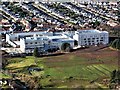
Largs Campus
The Largs Campus under construction.
The new Largs Campus is a state-of-the art £44 million education facility, which is being developed on behalf of North Ayrshire Council.
Due to open in March 2018, the project includes the relocation of Largs Academy and St Mary’s Primary School, plus the new Largs Primary School created by the amalgamation of Brisbane and Kelburn Primary Schools.
The Campus is being built on the grounds of the Sportscotland Inverclyde National Centre, allowing 2000 pupils accommodated in the new development access to state-of-the-art sporting facilities.
Image: © Raibeart MacAoidh
Taken: 6 Feb 2018
0.23 miles