IMAGES TAKEN NEAR TO
Routenburn Road, LARGS, KA30 8SQ
Introduction
This page details the photographs taken nearby to Routenburn Road, KA30 8SQ by members of the Geograph project.
The Geograph project started in 2005 with the aim of publishing, organising and preserving representative images for every square kilometre of Great Britain, Ireland and the Isle of Man.

There are currently over 7.5m images from over14,400 individuals and you can help contribute to the project by visiting https://www.geograph.org.uk
Image Map
Images are licensed for reuse under creativecommons.org/licenses/by-sa/2.0
Notes
- Clicking on the map will re-center to the selected point.
- The higher the marker number, the further away the image location is from the centre of the postcode.
Image Listing (99 Images Found)
Images are licensed for reuse under creativecommons.org/licenses/by-sa/2.0
Image
Details
Distance
1
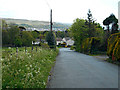
Routenburn Road
Looking down the hill near the golf course.
Image: © Thomas Nugent
Taken: 16 May 2015
0.02 miles
2
Routenburn Road
Looking down the hill near the golf course.
Image: © Thomas Nugent
Taken: 16 May 2015
0.02 miles
3
Routenburn Road
Looking down the hill past the golf course.
Image: © Thomas Nugent
Taken: 16 May 2015
0.02 miles
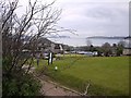
4
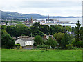
Largs from Netherhall
Looking over the town towards the pier and the Firth of Clyde from the road to Netherhall Farm.
Image: © Thomas Nugent
Taken: 6 Aug 2018
0.03 miles
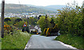
5

Largs from Netherhall
Routenburn Road is in the foreground, with the town centre and Hunterston Ore Terminal in the distance.
Image: © Thomas Nugent
Taken: 6 Aug 2018
0.03 miles
6
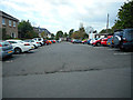
Car Park
At Routenburn golf club, off Routenburn Road.
Image: © Thomas Nugent
Taken: 16 May 2015
0.03 miles
9
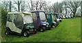
Carts at Routenburn Golf Club
Parked near the first tee.
Image: © Thomas Nugent
Taken: 8 Apr 2024
0.06 miles
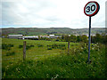
10
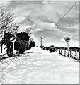
The Red Road - Largs
Routenburn Road is known locally as 'The Red Road'.
Image: © Raibeart MacAoidh
Taken: 1 Mar 2018
0.06 miles