IMAGES TAKEN NEAR TO
Greenock Road, LARGS, KA30 8SA
Introduction
This page details the photographs taken nearby to Greenock Road, KA30 8SA by members of the Geograph project.
The Geograph project started in 2005 with the aim of publishing, organising and preserving representative images for every square kilometre of Great Britain, Ireland and the Isle of Man.

There are currently over 7.5m images from over14,400 individuals and you can help contribute to the project by visiting https://www.geograph.org.uk
Image Map
Images are licensed for reuse under creativecommons.org/licenses/by-sa/2.0
Notes
- Clicking on the map will re-center to the selected point.
- The higher the marker number, the further away the image location is from the centre of the postcode.
Image Listing (36 Images Found)
Images are licensed for reuse under creativecommons.org/licenses/by-sa/2.0
Image
Details
Distance
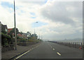
1
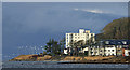
North Largs
Apartment buildings by the A78 Greenock Road, viewed from the pier.
Image: © Thomas Nugent
Taken: 29 Jan 2017
0.04 miles
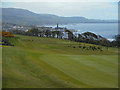
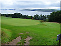
3
Routenburn Golf Course
with Largs in the background
Image: © william craig
Taken: 18 Oct 2005
0.11 miles
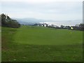
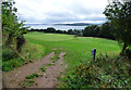
4
Routenburn golf course
Looking over the third fairway. Largs town centre can be seen in the distance.
Image: © Thomas Nugent
Taken: 16 May 2015
0.11 miles
5
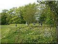
Routenburn Golf Club
Looking in to the course from Routenburn Road.
Image: © Thomas Nugent
Taken: 6 Aug 2018
0.11 miles
6
Routenburn Golf Club
Looking in to the course from Routenburn Road.
Image: © Thomas Nugent
Taken: 6 Aug 2018
0.11 miles
10
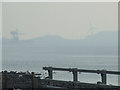
Hunterston from Largs
One of the ore cranes at the ore terminal and one of the wind turbines, seen through the mist from the north end of Largs.
Image: © Thomas Nugent
Taken: 17 Mar 2015
0.13 miles