IMAGES TAKEN NEAR TO
Merkland Park, KILMARNOCK, KA2 9JN
Introduction
This page details the photographs taken nearby to Merkland Park, KA2 9JN by members of the Geograph project.
The Geograph project started in 2005 with the aim of publishing, organising and preserving representative images for every square kilometre of Great Britain, Ireland and the Isle of Man.

There are currently over 7.5m images from over14,400 individuals and you can help contribute to the project by visiting https://www.geograph.org.uk
Image Map
Images are licensed for reuse under creativecommons.org/licenses/by-sa/2.0
Notes
- Clicking on the map will re-center to the selected point.
- The higher the marker number, the further away the image location is from the centre of the postcode.
Image Listing (52 Images Found)
Images are licensed for reuse under creativecommons.org/licenses/by-sa/2.0
Image
Details
Distance
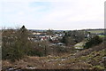
2
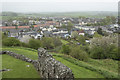
View from the roof
The view from the roof of Dundonald Castle is rather less impressive today as it is raining quite heavily.
Image: © Malcolm Neal
Taken: 8 May 2018
0.17 miles
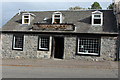
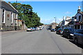
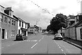
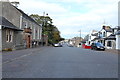
3
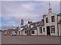
Main Street, Dundonald
Dundonald Inn (ctr) now closed.
Image: © wfmillar
Taken: 17 Aug 2010
0.17 miles