IMAGES TAKEN NEAR TO
Richmond Terrace, KILMARNOCK, KA2 9HL
Introduction
This page details the photographs taken nearby to Richmond Terrace, KA2 9HL by members of the Geograph project.
The Geograph project started in 2005 with the aim of publishing, organising and preserving representative images for every square kilometre of Great Britain, Ireland and the Isle of Man.

There are currently over 7.5m images from over14,400 individuals and you can help contribute to the project by visiting https://www.geograph.org.uk
Image Map
Images are licensed for reuse under creativecommons.org/licenses/by-sa/2.0
Notes
- Clicking on the map will re-center to the selected point.
- The higher the marker number, the further away the image location is from the centre of the postcode.
Image Listing (202 Images Found)
Images are licensed for reuse under creativecommons.org/licenses/by-sa/2.0
Image
Details
Distance
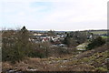
1
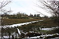
View from the roof
The view from the roof of Dundonald Castle is rather less impressive today as it is raining quite heavily.
Image: © Malcolm Neal
Taken: 8 May 2018
0.02 miles
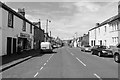
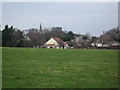
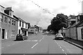
3
Main Street
Housing at the southern end of Main Street.
Image: © Jonathan Wilkins
Taken: 25 May 2018
0.03 miles
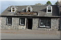
5
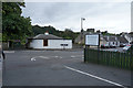
The Auchans
The Auchans is a restaurant bar that serves a decent lunch and for once was not very busy. This view is from the car park looking across the road to take in the sign for the establishment.
Image: © Malcolm Neal
Taken: 28 Aug 2019
0.04 miles
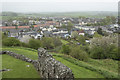
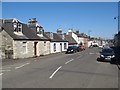
7
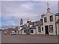
Main Street, Dundonald
Dundonald Inn (ctr) now closed.
Image: © wfmillar
Taken: 17 Aug 2010
0.06 miles