IMAGES TAKEN NEAR TO
Castle Drive, KILMARNOCK, KA2 9EL
Introduction
This page details the photographs taken nearby to Castle Drive, KA2 9EL by members of the Geograph project.
The Geograph project started in 2005 with the aim of publishing, organising and preserving representative images for every square kilometre of Great Britain, Ireland and the Isle of Man.

There are currently over 7.5m images from over14,400 individuals and you can help contribute to the project by visiting https://www.geograph.org.uk
Image Map
Images are licensed for reuse under creativecommons.org/licenses/by-sa/2.0
Notes
- Clicking on the map will re-center to the selected point.
- The higher the marker number, the further away the image location is from the centre of the postcode.
Image Listing (168 Images Found)
Images are licensed for reuse under creativecommons.org/licenses/by-sa/2.0
Image
Details
Distance

2
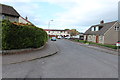
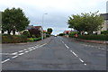
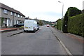
Gulliland Avenue, Dundonald
Leading to Castleview.
Image: © Billy McCrorie
Taken: 12 Oct 2013
0.03 miles
3
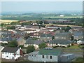
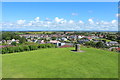
N/E from Dundonald
Looking down from Dundonald Castle hill on some of the local houses.
Image: © Derek Ferris
Taken: 9 Jun 2007
0.03 miles
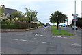
5
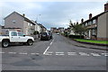
Castle Drive, Dundonald
Looking towards the school.
Image: © Billy McCrorie
Taken: 12 Oct 2013
0.05 miles