IMAGES TAKEN NEAR TO
Auchans Avenue, KILMARNOCK, KA2 9EB
Introduction
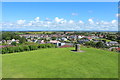
This page details the photographs taken nearby to Auchans Avenue, KA2 9EB by members of the Geograph project.
The Geograph project started in 2005 with the aim of publishing, organising and preserving representative images for every square kilometre of Great Britain, Ireland and the Isle of Man.

There are currently over 7.5m images from over14,400 individuals and you can help contribute to the project by visiting https://www.geograph.org.uk
Image Map
Images are licensed for reuse under creativecommons.org/licenses/by-sa/2.0
Notes
- Clicking on the map will re-center to the selected point.
- The higher the marker number, the further away the image location is from the centre of the postcode.
Image Listing (189 Images Found)
Images are licensed for reuse under creativecommons.org/licenses/by-sa/2.0
Image
Details
Distance


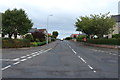
3
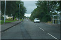
Showing recent roadworks
The road surface is patched as some work has been carried out recently, perhaps laying cables or pipes of some kind.
Image: © Malcolm Neal
Taken: 28 Aug 2019
0.03 miles