IMAGES TAKEN NEAR TO
Ploughland, KILMARNOCK, KA2 9BT
Introduction
This page details the photographs taken nearby to Ploughland, KA2 9BT by members of the Geograph project.
The Geograph project started in 2005 with the aim of publishing, organising and preserving representative images for every square kilometre of Great Britain, Ireland and the Isle of Man.

There are currently over 7.5m images from over14,400 individuals and you can help contribute to the project by visiting https://www.geograph.org.uk
Image Map (Loading...)


Getting Data...Please wait
Leaflet Map data © OpenStreetMap
Images are licensed for reuse under creativecommons.org/licenses/by-sa/2.0
Notes
- Clicking on the map will re-center to the selected point.
- The higher the marker number, the further away the image location is from the centre of the postcode.
Image Listing (40 Images Found)
Images are licensed for reuse under creativecommons.org/licenses/by-sa/2.0
Image
Details
Distance
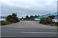
1
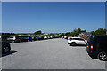
The garden centre car park
It is looking very hot as the sun reflects off the crushed limestone covering the car park.
Image: © Malcolm Neal
Taken: 30 May 2023
0.02 miles
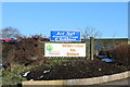
2
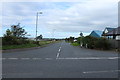
Jet Set Saddlery & Countrywear, Dundonald
Image: © Billy McCrorie
Taken: 22 May 2014
0.03 miles
3
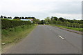
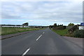
The B730 to Drybridge
On the left is the Olympic Business Park.
Image: © Billy McCrorie
Taken: 22 May 2014
0.04 miles
7
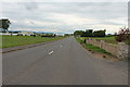
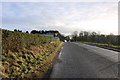
The B730 to Drybridge
On the right is Frasers Garden Centre.
Image: © Billy McCrorie
Taken: 12 Oct 2013
0.05 miles
10
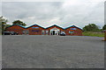
Frasers of Dundonald
Garden Centre.
Image: © Billy McCrorie
Taken: 12 Oct 2013
0.06 miles