IMAGES TAKEN NEAR TO
Gatehead, KILMARNOCK, KA2 9AY
Introduction
This page details the photographs taken nearby to KA2 9AY by members of the Geograph project.
The Geograph project started in 2005 with the aim of publishing, organising and preserving representative images for every square kilometre of Great Britain, Ireland and the Isle of Man.

There are currently over 7.5m images from over14,400 individuals and you can help contribute to the project by visiting https://www.geograph.org.uk
Image Map
Images are licensed for reuse under creativecommons.org/licenses/by-sa/2.0
Notes
- Clicking on the map will re-center to the selected point.
- The higher the marker number, the further away the image location is from the centre of the postcode.
Image Listing (12 Images Found)
Images are licensed for reuse under creativecommons.org/licenses/by-sa/2.0
Image
Details
Distance
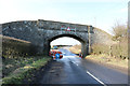
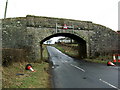
2
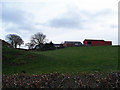
Templeton Farm
Old railway bridge on the left.
Image: © wfmillar
Taken: 12 Dec 2011
0.04 miles
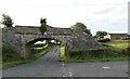
3
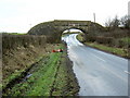
Bridge Near Templeton
Bridge left over from dismantled railway
Image: © Iain Thompson
Taken: 27 Jan 2007
0.06 miles
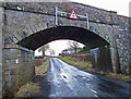
4
Low Bridge at Templeton
Old railway bridge.
Image: © Billy McCrorie
Taken: 15 Feb 2019
0.06 miles
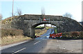
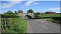
6
Templeton Farm
Old dismantled railway bridge crosses the B751.
Image: © wfmillar
Taken: 12 Dec 2011
0.07 miles
7
Low Bridge at Templeton
Old railway bridge.
Image: © Billy McCrorie
Taken: 15 Feb 2019
0.07 miles
8
Bridge at Templeton
Bridge left over from dismantled railway.
Image: © Iain Thompson
Taken: 27 Jan 2007
0.07 miles
9
Railway bridge, Templeton
The bridge is at the end of a mineral line which served Templeton Colliery.
Image: © Richard Webb
Taken: 21 May 2013
0.08 miles