IMAGES TAKEN NEAR TO
Symington, KILMARNOCK, KA2 9AT
Introduction
This page details the photographs taken nearby to KA2 9AT by members of the Geograph project.
The Geograph project started in 2005 with the aim of publishing, organising and preserving representative images for every square kilometre of Great Britain, Ireland and the Isle of Man.

There are currently over 7.5m images from over14,400 individuals and you can help contribute to the project by visiting https://www.geograph.org.uk
Image Map
Images are licensed for reuse under creativecommons.org/licenses/by-sa/2.0
Notes
- Clicking on the map will re-center to the selected point.
- The higher the marker number, the further away the image location is from the centre of the postcode.
Image Listing (6 Images Found)
Images are licensed for reuse under creativecommons.org/licenses/by-sa/2.0
Image
Details
Distance
1
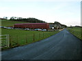
A wet morning under Ward Law
More rain on Ayrshire.
Image: © Richard Webb
Taken: 18 Jul 2012
0.20 miles
2
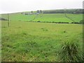
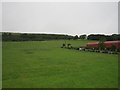
Farmland near Clevance
The green, green grass of lowland Ayrshire with Harpercroft communications mast on the skyline.
Image: © Mary and Angus Hogg
Taken: 31 Aug 2020
0.21 miles
3
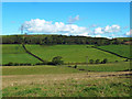
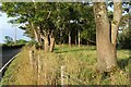
Road by Wester Croft
A minor road serving dairy farming country.
Image: © Richard Webb
Taken: 18 Jul 2012
0.23 miles
5
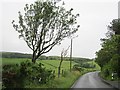
Langholm Farm
There is a farm shop here.
Image: © Richard Webb
Taken: 18 Jul 2012
0.24 miles