IMAGES TAKEN NEAR TO
Tarbolton Road, KILMARNOCK, KA2 9AR
Introduction
This page details the photographs taken nearby to Tarbolton Road, KA2 9AR by members of the Geograph project.
The Geograph project started in 2005 with the aim of publishing, organising and preserving representative images for every square kilometre of Great Britain, Ireland and the Isle of Man.

There are currently over 7.5m images from over14,400 individuals and you can help contribute to the project by visiting https://www.geograph.org.uk
Image Map
Images are licensed for reuse under creativecommons.org/licenses/by-sa/2.0
Notes
- Clicking on the map will re-center to the selected point.
- The higher the marker number, the further away the image location is from the centre of the postcode.
Image Listing (6 Images Found)
Images are licensed for reuse under creativecommons.org/licenses/by-sa/2.0
Image
Details
Distance
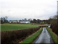
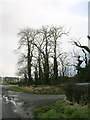
2
Approaching the cross road
By Crooks is a crossroad between a 'B road' and a minor road and you can just see the minor road on the left near the farm buildings.
Image: © Malcolm Neal
Taken: 28 Aug 2019
0.20 miles
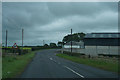
4
Crooks Farm
Looking NE from the minor road. The farm buildings lie beside the B730.
Image: © Mary and Angus Hogg
Taken: 1 Nov 2018
0.22 miles
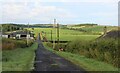
6
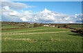
Towards Broomhill Farm
Grazing land in South Ayrshire near the village of Dundonald.
Image: © Mary and Angus Hogg
Taken: 1 Nov 2018
0.23 miles