IMAGES TAKEN NEAR TO
Gatehead, KILMARNOCK, KA2 9AN
Introduction
This page details the photographs taken nearby to KA2 9AN by members of the Geograph project.
The Geograph project started in 2005 with the aim of publishing, organising and preserving representative images for every square kilometre of Great Britain, Ireland and the Isle of Man.

There are currently over 7.5m images from over14,400 individuals and you can help contribute to the project by visiting https://www.geograph.org.uk
Image Map
Images are licensed for reuse under creativecommons.org/licenses/by-sa/2.0
Notes
- Clicking on the map will re-center to the selected point.
- The higher the marker number, the further away the image location is from the centre of the postcode.
Image Listing (9 Images Found)
Images are licensed for reuse under creativecommons.org/licenses/by-sa/2.0
Image
Details
Distance
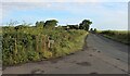
4
Arrothill Mount
View from the B751 near Peatland farm.
Image: © wfmillar
Taken: 12 Dec 2011
0.11 miles
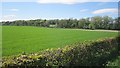
5

Harvested Field beside A759
Galrigside Farm in the distance.
Image: © wfmillar
Taken: 17 Aug 2010
0.17 miles
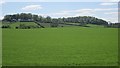
6
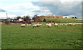
Farmland Near Gatehead
Viewed on the edge of the square on a bright early-November afternoon.
Image: © Mary and Angus Hogg
Taken: 1 Nov 2018
0.20 miles
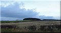
7
Arable land
Looking over a field towards one of the gatehouses at Fairlie House.
Image: © Richard Webb
Taken: 21 May 2013
0.21 miles
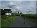
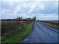
9

Road Junction
B751 joins the A759. Fairlie House Lodge on the left.
Image: © wfmillar
Taken: 17 Aug 2010
0.22 miles