IMAGES TAKEN NEAR TO
Fairlie Estate, KILMARNOCK, KA2 9AL
Introduction
This page details the photographs taken nearby to Fairlie Estate, KA2 9AL by members of the Geograph project.
The Geograph project started in 2005 with the aim of publishing, organising and preserving representative images for every square kilometre of Great Britain, Ireland and the Isle of Man.

There are currently over 7.5m images from over14,400 individuals and you can help contribute to the project by visiting https://www.geograph.org.uk
Image Map
Images are licensed for reuse under creativecommons.org/licenses/by-sa/2.0
Notes
- Clicking on the map will re-center to the selected point.
- The higher the marker number, the further away the image location is from the centre of the postcode.
Image Listing (3 Images Found)
Images are licensed for reuse under creativecommons.org/licenses/by-sa/2.0
Image
Details
Distance
2
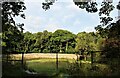
Walled garden of Fairlie House
Little used at present.
Image: © Alan Reid
Taken: 12 Aug 2021
0.07 miles
3
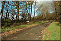
This Way to Fairlie Mains
An autumn view of this access road which connects with the A759.
Image: © Mary and Angus Hogg
Taken: 1 Nov 2018
0.18 miles