IMAGES TAKEN NEAR TO
KILMARNOCK, KA2 9AD
Introduction
This page details the photographs taken nearby to KA2 9AD by members of the Geograph project.
The Geograph project started in 2005 with the aim of publishing, organising and preserving representative images for every square kilometre of Great Britain, Ireland and the Isle of Man.

There are currently over 7.5m images from over14,400 individuals and you can help contribute to the project by visiting https://www.geograph.org.uk
Image Map
Images are licensed for reuse under creativecommons.org/licenses/by-sa/2.0
Notes
- Clicking on the map will re-center to the selected point.
- The higher the marker number, the further away the image location is from the centre of the postcode.
Image Listing (7 Images Found)
Images are licensed for reuse under creativecommons.org/licenses/by-sa/2.0
Image
Details
Distance
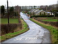
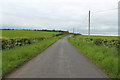
2
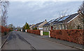
Earlston by Kilmarnock
Beech hedges on both sides.
Image: © wfmillar
Taken: 6 Mar 2012
0.01 miles
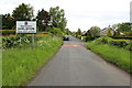
6
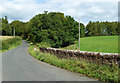
Todrigs Bridge
Todrigs Burn was difficult to see on this late-August visit due to the growth of vegetation.
Image: © Mary and Angus Hogg
Taken: 29 Aug 2020
0.21 miles
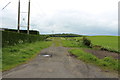
7
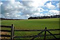
Fields and Woods Near Kilmarnock
An early spring view of grazing land near Kilmarnock.
Image: © Mary and Angus Hogg
Taken: 5 Mar 2017
0.22 miles