IMAGES TAKEN NEAR TO
KILMARNOCK, KA2 9AB
Introduction
This page details the photographs taken nearby to KA2 9AB by members of the Geograph project.
The Geograph project started in 2005 with the aim of publishing, organising and preserving representative images for every square kilometre of Great Britain, Ireland and the Isle of Man.

There are currently over 7.5m images from over14,400 individuals and you can help contribute to the project by visiting https://www.geograph.org.uk
Image Map
Images are licensed for reuse under creativecommons.org/licenses/by-sa/2.0
Notes
- Clicking on the map will re-center to the selected point.
- The higher the marker number, the further away the image location is from the centre of the postcode.
Image Listing (9 Images Found)
Images are licensed for reuse under creativecommons.org/licenses/by-sa/2.0
Image
Details
Distance
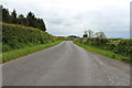
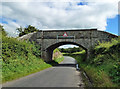
3
Minor Road to the A759 near Old Rome
Image: © Billy McCrorie
Taken: 22 May 2014
0.15 miles
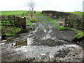
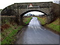
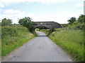
4
Old railway bridge
A substantial stone bridge on the disused railway line near Caprington.
Image: © Mary and Angus Hogg
Taken: 29 Aug 2020
0.17 miles
8
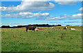
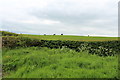
Arrothill cattle
A field with beef cattle at Arrothill, near Gatehead.
Image: © Mary and Angus Hogg
Taken: 29 Aug 2020
0.20 miles