IMAGES TAKEN NEAR TO
Caprington Estate, KILMARNOCK, KA2 9AA
Introduction
This page details the photographs taken nearby to Caprington Estate, KA2 9AA by members of the Geograph project.
The Geograph project started in 2005 with the aim of publishing, organising and preserving representative images for every square kilometre of Great Britain, Ireland and the Isle of Man.

There are currently over 7.5m images from over14,400 individuals and you can help contribute to the project by visiting https://www.geograph.org.uk
Image Map
Images are licensed for reuse under creativecommons.org/licenses/by-sa/2.0
Notes
- Clicking on the map will re-center to the selected point.
- The higher the marker number, the further away the image location is from the centre of the postcode.
Image Listing (7 Images Found)
Images are licensed for reuse under creativecommons.org/licenses/by-sa/2.0
Image
Details
Distance
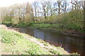
1
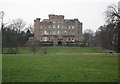
Caprington Castle
Majestic house home of Cuninghames and the very helpful Mrs Cuninghame. Great to walk around and great for snowdrops at this time of year.
Image: © wfmillar
Taken: 9 Feb 2007
0.09 miles
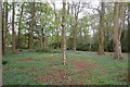
3
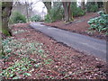
Snowdrops
On the drive at Caprington Castle.
Image: © wfmillar
Taken: 9 Feb 2007
0.16 miles
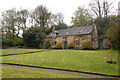
4
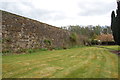
Walled garden
I think this is the walled garden of Caprington estate.
Image: © Scott
Taken: 27 Apr 2012
0.19 miles
6
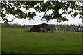
Old stone building
Not sure what this is, maybe something to do with a well or water source. There's 2 of them in this field, approx 50 metres apart.
Image: © Scott
Taken: 27 Apr 2012
0.20 miles
7
Derelict cottage
Derelict cottage near walled garden
Image: © Scott
Taken: 27 Apr 2012
0.20 miles