IMAGES TAKEN NEAR TO
Pier Road, LARGS, KA29 0AP
Introduction
This page details the photographs taken nearby to Pier Road, KA29 0AP by members of the Geograph project.
The Geograph project started in 2005 with the aim of publishing, organising and preserving representative images for every square kilometre of Great Britain, Ireland and the Isle of Man.

There are currently over 7.5m images from over14,400 individuals and you can help contribute to the project by visiting https://www.geograph.org.uk
Image Map
Images are licensed for reuse under creativecommons.org/licenses/by-sa/2.0
Notes
- Clicking on the map will re-center to the selected point.
- The higher the marker number, the further away the image location is from the centre of the postcode.
Image Listing (144 Images Found)
Images are licensed for reuse under creativecommons.org/licenses/by-sa/2.0
Image
Details
Distance
1
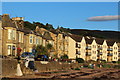
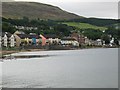
Seafront Flats on Allanton Park Terrace & Bay Street, Fairlie
Image: © Leslie Barrie
Taken: 4 Aug 2013
0.01 miles
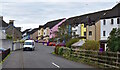
2
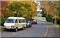
Pier Road, Fairlie, North Ayrshire
Looking down Pier Road, with Pier Crescent to the right.
Image: © Mark S
Taken: 15 Oct 2020
0.02 miles
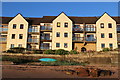
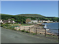
7
Fairlie
View towards the seafront flats on Allanton Park Terrace and Bay Street.
Image: © Leslie Barrie
Taken: 4 Aug 2013
0.05 miles
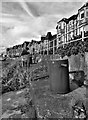
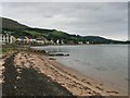
8
The beach at Fairlie
looking south from Pier Road.
Image: © Thomas Nugent
Taken: 19 Jun 2010
0.05 miles
9
Bay Street, Fairlie, North Ayrshire
A colourful view along Bay Street.
Image: © Mark S
Taken: 15 Oct 2020
0.05 miles
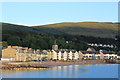
10
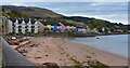
Fairlie, North Ayrshire
Sea view properties and the beach at Fairlie.
Image: © Mark S
Taken: 15 Oct 2020
0.05 miles