IMAGES TAKEN NEAR TO
Ferry Row, LARGS, KA29 0AJ
Introduction
This page details the photographs taken nearby to Ferry Row, KA29 0AJ by members of the Geograph project.
The Geograph project started in 2005 with the aim of publishing, organising and preserving representative images for every square kilometre of Great Britain, Ireland and the Isle of Man.

There are currently over 7.5m images from over14,400 individuals and you can help contribute to the project by visiting https://www.geograph.org.uk
Image Map
Images are licensed for reuse under creativecommons.org/licenses/by-sa/2.0
Notes
- Clicking on the map will re-center to the selected point.
- The higher the marker number, the further away the image location is from the centre of the postcode.
Image Listing (134 Images Found)
Images are licensed for reuse under creativecommons.org/licenses/by-sa/2.0
Image
Details
Distance
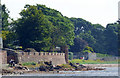
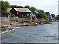
1
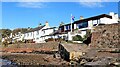
Ferry Row - Fairlie
Ferry Row was formerly a row of humble fishermen's cottages and was known as Middle Row.
Image: © Raibeart MacAoidh
Taken: 22 Oct 2023
0.00 miles
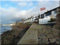
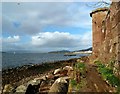
4
Ferry Row - Fairlie
Ferry Row from the Old Ferry Quay
Image: © Raibeart MacAoidh
Taken: 28 Nov 2017
0.02 miles
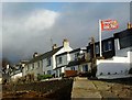
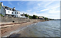
5
Seafront houses in Fairlie
Viewed from the beach at Bay Street.
Image: © Thomas Nugent
Taken: 14 Jul 2018
0.02 miles
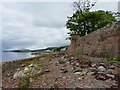
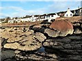
7
Fairlie Sands
Seawall at Fairlie Sands
Image: © Raibeart MacAoidh
Taken: 26 Oct 2017
0.03 miles
8
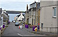
The Causeway, Fairlie, North Ayrshire
The view down The Causeway from Main Road.
Image: © Mark S
Taken: 15 Oct 2020
0.04 miles
9
Seafront houses in Fairlie
Viewed from the beach at Bay Street.
Image: © Thomas Nugent
Taken: 14 Jul 2018
0.04 miles
10
Seafront houses in Fairlie
Viewed from the beach at Bay Street.
Image: © Thomas Nugent
Taken: 14 Jul 2018
0.04 miles