IMAGES TAKEN NEAR TO
Main Road, LARGS, KA29 0AB
Introduction
This page details the photographs taken nearby to Main Road, KA29 0AB by members of the Geograph project.
The Geograph project started in 2005 with the aim of publishing, organising and preserving representative images for every square kilometre of Great Britain, Ireland and the Isle of Man.

There are currently over 7.5m images from over14,400 individuals and you can help contribute to the project by visiting https://www.geograph.org.uk
Image Map
Images are licensed for reuse under creativecommons.org/licenses/by-sa/2.0
Notes
- Clicking on the map will re-center to the selected point.
- The higher the marker number, the further away the image location is from the centre of the postcode.
Image Listing (139 Images Found)
Images are licensed for reuse under creativecommons.org/licenses/by-sa/2.0
Image
Details
Distance
2
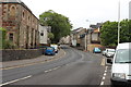
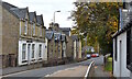
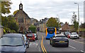
Main Road, Fairlie, North Ayrshire
The A78 in Fairlie.
The gable end of the first building on the right was partially demolished by an articulated lorry after its driver fell ill at the wheel in February 2013.
Image: © Mark S
Taken: 15 Oct 2020
0.01 miles
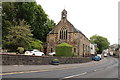
4
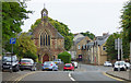
Former St Margaret's church
Category C Listed http://portal.historicenvironment.scot/designation/LB7291 former church on Main Road. Now appears to be in residential use.
The ground floor was built in 1834 and the upper floor with the oculus was added in 1879.
Image: © Thomas Nugent
Taken: 13 Jul 2018
0.01 miles
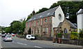
5
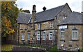
Library & Village Hall, Fairlie, North Ayrshire
Opened in November 1892 as the Parker Memorial Hall.
The building is Category B Listed.
Image: © Mark S
Taken: 15 Oct 2020
0.01 miles
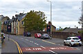
6
Main Road, Fairlie, North Ayrshire
The Semple Centre is on the left.
Image: © Mark S
Taken: 15 Oct 2020
0.01 miles
7
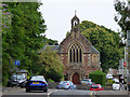
Former St Margaret's Church, Fairlie
Category C Listed http://portal.historicenvironment.scot/designation/LB7291 former church on Main Road. Now appears to be in residential use.
Image: © Thomas Nugent
Taken: 13 Jul 2018
0.02 miles
8
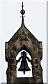
Former St Margaret's Church, Fairlie
The small belfry on the Category C Listed http://portal.historicenvironment.scot/designation/LB7291 former church on Main Road. The church Now appears to be in residential use.
Image: © Thomas Nugent
Taken: 13 Jul 2018
0.02 miles
9
Former St Margaret's Church, Fairlie
Category C Listed http://portal.historicenvironment.scot/designation/LB7291 former church on Main Road. Now appears to be in residential use.
Image: © Thomas Nugent
Taken: 13 Jul 2018
0.02 miles
10
Main Road, Fairlie, North Ayrshire
The former St Margaret’s Church.
Category C Listed and now a private residence.
Image: © Mark S
Taken: 15 Oct 2020
0.02 miles