IMAGES TAKEN NEAR TO
Main Road, LARGS, KA29 0AA
Introduction
This page details the photographs taken nearby to Main Road, KA29 0AA by members of the Geograph project.
The Geograph project started in 2005 with the aim of publishing, organising and preserving representative images for every square kilometre of Great Britain, Ireland and the Isle of Man.

There are currently over 7.5m images from over14,400 individuals and you can help contribute to the project by visiting https://www.geograph.org.uk
Image Map
Images are licensed for reuse under creativecommons.org/licenses/by-sa/2.0
Notes
- Clicking on the map will re-center to the selected point.
- The higher the marker number, the further away the image location is from the centre of the postcode.
Image Listing (156 Images Found)
Images are licensed for reuse under creativecommons.org/licenses/by-sa/2.0
Image
Details
Distance
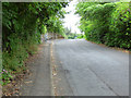
1
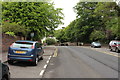
Main Road, Fairlie
On the way to Largs.
Image: © Billy McCrorie
Taken: 3 Jun 2013
0.02 miles
2
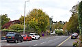
Main Road, Fairlie, North Ayrshire
The A78 in Fairlie.
Image: © Mark S
Taken: 15 Oct 2020
0.02 miles
3
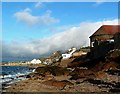
The Pine House - Fairlie Sands
Looking towards Bay Street, Fairlie from The Pine House at Fairlie Sands.
Image: © Raibeart MacAoidh
Taken: 3 Jan 2017
0.03 miles
4
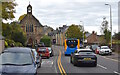
Main Road, Fairlie, North Ayrshire
The former St Margaret’s Church.
Category C Listed and now a private residence.
Image: © Mark S
Taken: 15 Oct 2020
0.03 miles
5
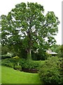
Big tree, little pond
A fine specimen of a sycamore in a Fairlie garden.
Image: © James Allan
Taken: 18 Jul 2012
0.04 miles
6
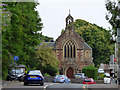
Former St Margaret's Church, Fairlie
Category C Listed http://portal.historicenvironment.scot/designation/LB7291 former church on Main Road. Now appears to be in residential use.
Image: © Thomas Nugent
Taken: 13 Jul 2018
0.04 miles
7
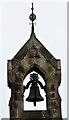
Former St Margaret's Church, Fairlie
The small belfry on the Category C Listed http://portal.historicenvironment.scot/designation/LB7291 former church on Main Road. The church Now appears to be in residential use.
Image: © Thomas Nugent
Taken: 13 Jul 2018
0.04 miles
8
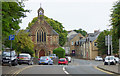
Former St Margaret's Church, Fairlie
Category C Listed http://portal.historicenvironment.scot/designation/LB7291 former church on Main Road. Now appears to be in residential use.
Image: © Thomas Nugent
Taken: 13 Jul 2018
0.04 miles
9
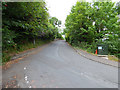
School Brae
Looking up the brae from the A78 main Road.
Image: © Thomas Nugent
Taken: 13 Jul 2018
0.04 miles
10
School Brae
Looking up the brae from the A78 main Road.
Image: © Thomas Nugent
Taken: 13 Jul 2018
0.04 miles