IMAGES TAKEN NEAR TO
College Street, ISLE OF CUMBRAE, KA28 0DH
Introduction
This page details the photographs taken nearby to College Street, KA28 0DH by members of the Geograph project.
The Geograph project started in 2005 with the aim of publishing, organising and preserving representative images for every square kilometre of Great Britain, Ireland and the Isle of Man.

There are currently over 7.5m images from over14,400 individuals and you can help contribute to the project by visiting https://www.geograph.org.uk
Image Map
Images are licensed for reuse under creativecommons.org/licenses/by-sa/2.0
Notes
- Clicking on the map will re-center to the selected point.
- The higher the marker number, the further away the image location is from the centre of the postcode.
Image Listing (331 Images Found)
Images are licensed for reuse under creativecommons.org/licenses/by-sa/2.0
Image
Details
Distance
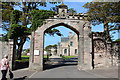
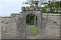
3
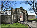
Gateway at the east end of the grounds of The Garrison
Dates from about 1820.
Image: © Jonathan Thacker
Taken: 31 Mar 2016
0.02 miles
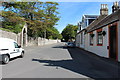
4
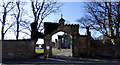
East Gates at The Garrison
On College Street.
Image: © Thomas Nugent
Taken: 25 Feb 2018
0.02 miles
5
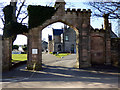
East Gates at The Garrison
On College Street.
Image: © Thomas Nugent
Taken: 25 Feb 2018
0.02 miles
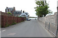
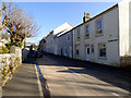
8
Glasgow Street, Millport - Isle of Cumbrae
Glasgow Street from Newton Bay
Image: © Raibeart MacAoidh
Taken: 12 Mar 2018
0.03 miles