IMAGES TAKEN NEAR TO
Kildonan, ISLE OF ARRAN, KA27 8SD
Introduction
This page details the photographs taken nearby to KA27 8SD by members of the Geograph project.
The Geograph project started in 2005 with the aim of publishing, organising and preserving representative images for every square kilometre of Great Britain, Ireland and the Isle of Man.

There are currently over 7.5m images from over14,400 individuals and you can help contribute to the project by visiting https://www.geograph.org.uk
Image Map
Images are licensed for reuse under creativecommons.org/licenses/by-sa/2.0
Notes
- Clicking on the map will re-center to the selected point.
- The higher the marker number, the further away the image location is from the centre of the postcode.
Image Listing (17 Images Found)
Images are licensed for reuse under creativecommons.org/licenses/by-sa/2.0
Image
Details
Distance
1
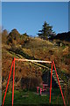
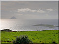
View from above Kildonan
The lighthouse is on the small island of Pladda, with Ailsa Craig and the Ayrshire mainland beyond.
Image: © Gordon Brown
Taken: 24 Aug 2020
0.07 miles
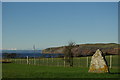
2
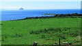
Kildonan and Pladda
Grassland at Kildonan with Pladda beyond. Southern Arran has a lot of grassland and supports dairy farming. A creamery takes the milk to make cheese.
Image: © Richard Webb
Taken: 18 Oct 2011
0.12 miles
3
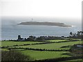
A View towards Pladda and Ailsa Craig
Taken from the former A841 road near to Kildonan.
Image: © David Dixon
Taken: 23 Sep 2019
0.12 miles
4
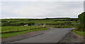
The road heading east from Kildonan, Arran
Image: © habiloid
Taken: 18 Aug 2023
0.17 miles
5
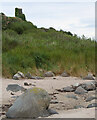
A ruined lookout tower seen from Silver Sands, Kildonan, Arran
Image: © habiloid
Taken: 18 Aug 2023
0.18 miles
6
Kildonan Castle
Dating from the 13th-century and once a property of the MacDonald Lord of the Isles
Image: © Leslie Barrie
Taken: 27 Nov 2012
0.19 miles
7
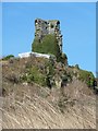
Kildonan Castle (remains)
Not much survives of the once royal hunting lodge of Kildonan Castle on the southern tip of the Isle of Arran. Built originally by the MacDonalds, Lords of the Isles, in the late C13th or early C14th it passed into royal hands when the whole of Arran came under their sway in the C15th. The Hamiltons, Earls of Arran, took ownership of the castle in 1544 but it has suffered very badly over the following centuries. It now stands in a private garden, this view being from the beach.
Image: © Rob Farrow
Taken: 1 Apr 2013
0.19 miles
8
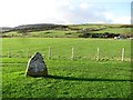
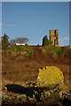
Standing stone, Kildonan
An isolated standing stone. The surrounding land has been used as a car park.
Image: © Richard Webb
Taken: 18 Oct 2011
0.19 miles
9
Standing Stone at Kildonan
The only remaining stone from a stone circle cleared away many years ago during the construction of the road
Image: © Leslie Barrie
Taken: 27 Nov 2012
0.20 miles