IMAGES TAKEN NEAR TO
Whiting Bay, ISLE OF ARRAN, KA27 8RJ
Introduction
This page details the photographs taken nearby to KA27 8RJ by members of the Geograph project.
The Geograph project started in 2005 with the aim of publishing, organising and preserving representative images for every square kilometre of Great Britain, Ireland and the Isle of Man.

There are currently over 7.5m images from over14,400 individuals and you can help contribute to the project by visiting https://www.geograph.org.uk
Image Map
Images are licensed for reuse under creativecommons.org/licenses/by-sa/2.0
Notes
- Clicking on the map will re-center to the selected point.
- The higher the marker number, the further away the image location is from the centre of the postcode.
Image Listing (10 Images Found)
Images are licensed for reuse under creativecommons.org/licenses/by-sa/2.0
Image
Details
Distance
1
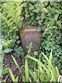
Old Milestone by the A841, Kilbride parish
Arran by the A841, in parish of Kilbride (Arran District), top of sharp rise opposite houses, in deep ditch under hedge.
Inscription reads:-
11
(To Brodick Old Quay)
Surveyed
Milestone Society National ID: AYN_ARR11
Image: © Milestone Society
Taken: Unknown
0.02 miles
2
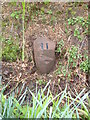
Milestone 11, Arran
Newly painted number. This milestone was nearly lost for ever as it was completely buried, luckily a neighbour knew where it was but it still took a while to find.
Image: © Brian Robertson
Taken: 13 Mar 2012
0.03 miles
4
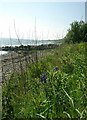
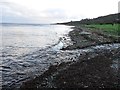
Shore at Largymore
Looking south towards Largybeg point. This is taken from close to the outflow of the Allt Crompucaidh.
Image: © Callum Black
Taken: 30 Oct 2008
0.13 miles
6
Allt Crompucaidh outflow
The Allt Crompucaidh meets the sea at Largymore.
Image: © Richard Webb
Taken: 18 Oct 2011
0.15 miles
7
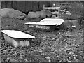
Baths
Near the roadside at Largymore. Awaiting a new life as water troughs.
Image: © Callum Black
Taken: 30 Oct 2008
0.16 miles
8
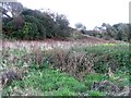
Raised beach, Largymore
This section of the former beach, now left high and dry after the land rebounded, is uncultivated. The rising of the land is due to the loss of an ice cap.
Image: © Richard Webb
Taken: 18 Oct 2011
0.19 miles
9
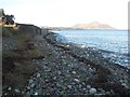
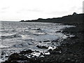
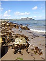
Shore at Largymore
A stone beach, looking northwards towards Holy Island.
Image: © Richard Webb
Taken: 18 Oct 2011
0.20 miles
10
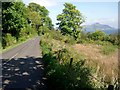
The road near Largybeg
Holy Isle and its lighthouse in the distance.
Image: © Gordon Brown
Taken: 13 May 2007
0.24 miles