IMAGES TAKEN NEAR TO
Lamlash, ISLE OF ARRAN, KA27 8PL
Introduction
This page details the photographs taken nearby to KA27 8PL by members of the Geograph project.
The Geograph project started in 2005 with the aim of publishing, organising and preserving representative images for every square kilometre of Great Britain, Ireland and the Isle of Man.

There are currently over 7.5m images from over14,400 individuals and you can help contribute to the project by visiting https://www.geograph.org.uk
Image Map
Images are licensed for reuse under creativecommons.org/licenses/by-sa/2.0
Notes
- Clicking on the map will re-center to the selected point.
- The higher the marker number, the further away the image location is from the centre of the postcode.
Image Listing (10 Images Found)
Images are licensed for reuse under creativecommons.org/licenses/by-sa/2.0
Image
Details
Distance
1
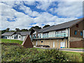
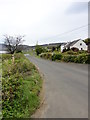
Arran Outdoor Education Centre
The centre is acting as the local Community Support Hub for Arran during the 2020 coronavirus pandemic.
Image: © John Allan
Taken: 31 Aug 2020
0.00 miles
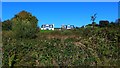
2
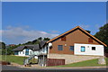
Arran Outdoor Education Centre, Lamlash
The inscription on the cairn (pictured bottom right) reads 'Arran Outdoor Education Centre was formally opened on Friday 3rd October 2008 by Councillor David O'Neill, leader of North Ayrshire Council'.
Image: © Leslie Barrie
Taken: 20 Jul 2013
0.01 miles
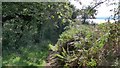
3
Arran Outdoor Education Centre, Lamlash
Image: © Leslie Barrie
Taken: 20 Jul 2013
0.01 miles
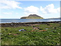
5
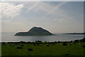
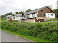
Clauchlands Farmland, Lamlash, Arran
This photo was taken from the road to Clauchlands Farm and shows Lamlash Bay, Holy Island and Kings Cross in the distance (please see supplemental photo for picture of the photographer's assistant!)
Image: © L J Cunningham
Taken: 6 Jun 2006
0.09 miles
6
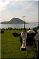
Clauchlands Farmland, Lamlash, Arran
Sorry, I have a thing about cows!
Image: © L J Cunningham
Taken: 6 Jun 2006
0.09 miles