IMAGES TAKEN NEAR TO
Sliddery, ISLE OF ARRAN, KA27 8PE
Introduction
This page details the photographs taken nearby to KA27 8PE by members of the Geograph project.
The Geograph project started in 2005 with the aim of publishing, organising and preserving representative images for every square kilometre of Great Britain, Ireland and the Isle of Man.

There are currently over 7.5m images from over14,400 individuals and you can help contribute to the project by visiting https://www.geograph.org.uk
Image Map
Images are licensed for reuse under creativecommons.org/licenses/by-sa/2.0
Notes
- Clicking on the map will re-center to the selected point.
- The higher the marker number, the further away the image location is from the centre of the postcode.
Image Listing (4 Images Found)
Images are licensed for reuse under creativecommons.org/licenses/by-sa/2.0
Image
Details
Distance
1
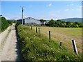
"The Moor" above Corriecravie
Not a description of terrain, but the name of the farm here.
Image: © Gordon Brown
Taken: 26 Jun 2009
0.01 miles
2
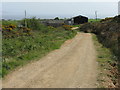
The Moor
A farm above Corricravie, from the road to Corriecravie Moor.
Image: © M J Richardson
Taken: 9 May 2011
0.01 miles
4
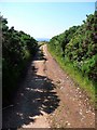
The track from Corriecravie Moor
The water of Kilbrannan Sound just visible in the distance.
Image: © Gordon Brown
Taken: 26 Jun 2009
0.16 miles