IMAGES TAKEN NEAR TO
Benlister Road, ISLE OF ARRAN, KA27 8LW
Introduction
This page details the photographs taken nearby to Benlister Road, KA27 8LW by members of the Geograph project.
The Geograph project started in 2005 with the aim of publishing, organising and preserving representative images for every square kilometre of Great Britain, Ireland and the Isle of Man.

There are currently over 7.5m images from over14,400 individuals and you can help contribute to the project by visiting https://www.geograph.org.uk
Image Map
Images are licensed for reuse under creativecommons.org/licenses/by-sa/2.0
Notes
- Clicking on the map will re-center to the selected point.
- The higher the marker number, the further away the image location is from the centre of the postcode.
Image Listing (9 Images Found)
Images are licensed for reuse under creativecommons.org/licenses/by-sa/2.0
Image
Details
Distance
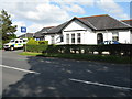
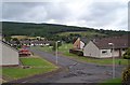
1
Scrubland at the end of McKelvie Road
Facing northwestwest from the car park of the Kirk Care home.
Image: © Alisdair Mclean
Taken: 15 Mar 2000
0.04 miles
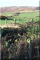
4
McKelvie Road, Lamlash
Mckelvie Road is named after Donald McKelvie who developed famous breeds of potato such as Arran Pilot and Arran Victory.
Image: © Alisdair Mclean
Taken: 15 Mar 2000
0.13 miles
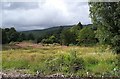
6
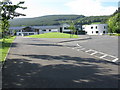
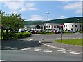
Education at Lamlash
Arran High School, Lamlash Primary School, Child Outreach, and Community Learning and Development. The forest plantations beyond are on Meall Buidhe
Image: © M J Richardson
Taken: 8 May 2011
0.21 miles
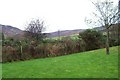
7
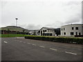
View of the Ross hill from Arran High School
Image: © Brian Robertson
Taken: 19 Aug 2012
0.21 miles
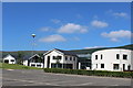
8
The new Arran High School at Lamlash
This fine building also incorporates community facilities.
Image: © Gordon Brown
Taken: 25 Jun 2009
0.22 miles