IMAGES TAKEN NEAR TO
Manse Road, ISLE OF ARRAN, KA27 8LP
Introduction
This page details the photographs taken nearby to Manse Road, KA27 8LP by members of the Geograph project.
The Geograph project started in 2005 with the aim of publishing, organising and preserving representative images for every square kilometre of Great Britain, Ireland and the Isle of Man.

There are currently over 7.5m images from over14,400 individuals and you can help contribute to the project by visiting https://www.geograph.org.uk
Image Map
Images are licensed for reuse under creativecommons.org/licenses/by-sa/2.0
Notes
- Clicking on the map will re-center to the selected point.
- The higher the marker number, the further away the image location is from the centre of the postcode.
Image Listing (27 Images Found)
Images are licensed for reuse under creativecommons.org/licenses/by-sa/2.0
Image
Details
Distance
2
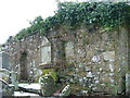
The Ruined Chapel of St Bridget in the Cemetery at Lamlash
The local cemetery of Lamlash on the Isle of Arran in Scotland has developed around this old (14th century) chapel ruin.
Image: © Dave Napier
Taken: 5 Feb 2009
0.05 miles
3
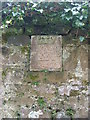
Wall Plaque on chapel of St Bridget
This stone plaque is set into the wall of the ruined chapel of St Bridget in the cemetery at Lamlash. It relates to the Hamilton family, the motto is 'Fir God' (for God) and the date is 1618.
Image: © Dave Napier
Taken: 5 Feb 2009
0.08 miles
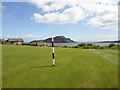
5
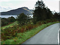
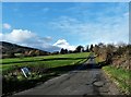
View towards Holy Island from the Lamlash Road (A841)
The Holy Island (Scottish Gaelic: Eilean MoLaise) in Lamlash Bay, is one of a number of islands in the United Kingdom which go under the name "Holy Island". It has a long history as a sacred site, with a spring or holy well held to have healing properties, the hermit cave of 6th century monk St Molaise, and evidence of a 13th-century monastery
Image: © David Dixon
Taken: 23 Sep 2019
0.16 miles
6
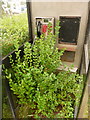
Lamlash: hedge inside phone box
A look inside the Image, showing that the shoots from the hedge outside have reached quite a height.
Although bereft of any information displays, I lifted the receiver and did obtain a dialling tone.
Image: © Chris Downer
Taken: 27 Sep 2010
0.19 miles
7
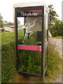
Lamlash: phone box in Bungalow Road
This telephone box is almost trying to be a greenhouse, with vegetation spreading from the adjacent hedge right into the box. For a view inside, see Image
Image: © Chris Downer
Taken: 27 Sep 2010
0.19 miles
8
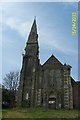
Derelict Church Lamlash Isle of Arran
A sad fate for a beautiful old church begging to be restored
Image: © paul birrell
Taken: 15 Apr 2003
0.21 miles
9
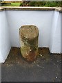
Milestone 5, Lamlash, Isle of Arran
Arran's circular road and The String road contain a total of approximately 50 milestones, marking, I believe, the miles round the island. There is a book, 'The Milestones of Arran' by Ruth and Alan Thompson, dedicated to them, listing not only the view from each, but also details of flora and fauna to be found at each location.
Some of the milestones were difficult to locate whilst driving in the rain, others were damaged and some appeared to be missing. I have added those that I could safely stop at and those that I could find.
No. 5 is on a busy road heading northwest out of Lamlash towards Brodick.
Image: © Becky Williamson
Taken: 10 Jul 2010
0.21 miles
10
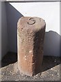
Old Milestone by the A841 in Margnaheglish
Arran milestone by the A841, in parish of Kilbride (Arran District), on hill in front of white house, enclosed on 3 sides by breezeblock wall 2006.
Inscription reads:-
5
(To Brodick Old Quay)
Surveyed
Milestone Society National ID: AYN_ARR05
Image: © Milestone Society
Taken: Unknown
0.21 miles