IMAGES TAKEN NEAR TO
Hillfoot Place, ISLE OF ARRAN, KA27 8JL
Introduction
This page details the photographs taken nearby to Hillfoot Place, KA27 8JL by members of the Geograph project.
The Geograph project started in 2005 with the aim of publishing, organising and preserving representative images for every square kilometre of Great Britain, Ireland and the Isle of Man.

There are currently over 7.5m images from over14,400 individuals and you can help contribute to the project by visiting https://www.geograph.org.uk
Image Map
Images are licensed for reuse under creativecommons.org/licenses/by-sa/2.0
Notes
- Clicking on the map will re-center to the selected point.
- The higher the marker number, the further away the image location is from the centre of the postcode.
Image Listing (53 Images Found)
Images are licensed for reuse under creativecommons.org/licenses/by-sa/2.0
Image
Details
Distance
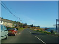
5
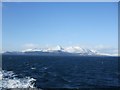
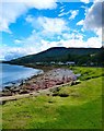
Northern Arran
A view from the Ferry home on a crisp winter morning in 2009.
Image: © Ashley Dace
Taken: Unknown
0.05 miles
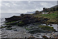
6
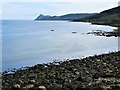
East Coast of Arran
Looking south from a small harbour just south of the small village of Corrie.
Image: © G Laird
Taken: 12 May 2018
0.07 miles
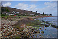
7
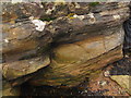
Cross stratified Permian Sandstones
Image: © Matthew Chadwick
Taken: 29 Mar 2014
0.08 miles
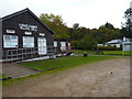
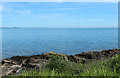
10
High Corrie
View south from the Sandstone Quay at Corrie.
Image: © Andy Farrington
Taken: 28 Jul 2012
0.09 miles