IMAGES TAKEN NEAR TO
Kinneil Park, ISLE OF ARRAN, KA27 8JG
Introduction
This page details the photographs taken nearby to Kinneil Park, KA27 8JG by members of the Geograph project.
The Geograph project started in 2005 with the aim of publishing, organising and preserving representative images for every square kilometre of Great Britain, Ireland and the Isle of Man.

There are currently over 7.5m images from over14,400 individuals and you can help contribute to the project by visiting https://www.geograph.org.uk
Image Map
Images are licensed for reuse under creativecommons.org/licenses/by-sa/2.0
Notes
- Clicking on the map will re-center to the selected point.
- The higher the marker number, the further away the image location is from the centre of the postcode.
Image Listing (78 Images Found)
Images are licensed for reuse under creativecommons.org/licenses/by-sa/2.0
Image
Details
Distance
1
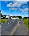
Leaving Lamlash
Travelling out of Lamlash anti-clockwise around Arran with Brodick the next stop in 3 miles.
Image: © Andy Farrington
Taken: 26 Jul 2012
0.04 miles
2
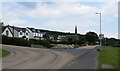
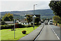
The junction of Main Street (A841) and Clauchlands Road, Lamlash, Arran
The Arran Coastal Way follows Main Street on to Clauchlands Road here.
Image: © habiloid
Taken: 17 Aug 2023
0.04 miles
3
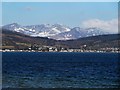
Lamlash and Margnaheglish across Lamlash Bay
A view across Lamlash Bay to the villages of Lamlash and Margnaheglish with the mountains of northern Arran forming a fine backdrop. Taken from the northwestern side of Kingscross Point.
Image: © Rob Farrow
Taken: 3 Apr 2013
0.04 miles
4
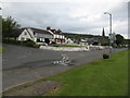
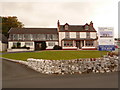
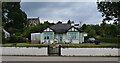
Marine Villas
Holiday accommodation at Lamlash, at the junction of the round-island road [A841] and the road to Clauchlands.
Image: © M J Richardson
Taken: 10 May 2011
0.05 miles
5
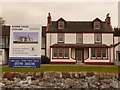
Lamlash: a closer look at Marine House
A close-up of Image and the artist's impression of the building which is soon to replace it.
Image: © Chris Downer
Taken: 27 Sep 2010
0.05 miles
6
Lamlash: Marine House
This building, which perhaps was a nursing home or somesuch, stands on the corner where the main road leaves the coast. It is disused and up for demolition and replacement, according to the artist's impression of what the plot will look like. For a closer look, see Image
Image: © Chris Downer
Taken: 27 Sep 2010
0.05 miles
7
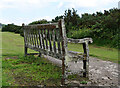
Bench, Main Street (A841), Lamlash, Arran
This bench can be seen in context in Image
Image: © habiloid
Taken: 17 Aug 2023
0.06 miles
8
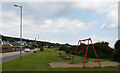
Playground, Main Street (A841), Lamlash, Arran
The Arran Coastal Way follows the road here. A close-up of the bench beyond the table can be seen in Image
Image: © habiloid
Taken: 17 Aug 2023
0.06 miles
9
Briarbank, Main Street (A841), Lamlash, Arran
Image: © habiloid
Taken: 17 Aug 2023
0.07 miles
10
Lamlash, Isle of Arran
Lamlash (Scottish Gaelic: An t-Eilean Àrd) is the largest village on the Isle of Arran. It is situated in a sheltered bay on the island's east coast, 3 miles to the south of ferry port Brodick.
Image: © David Dixon
Taken: 23 Sep 2019
0.07 miles