IMAGES TAKEN NEAR TO
Corrie, ISLE OF ARRAN, KA27 8JB
Introduction
This page details the photographs taken nearby to KA27 8JB by members of the Geograph project.
The Geograph project started in 2005 with the aim of publishing, organising and preserving representative images for every square kilometre of Great Britain, Ireland and the Isle of Man.

There are currently over 7.5m images from over14,400 individuals and you can help contribute to the project by visiting https://www.geograph.org.uk
Image Map
Images are licensed for reuse under creativecommons.org/licenses/by-sa/2.0
Notes
- Clicking on the map will re-center to the selected point.
- The higher the marker number, the further away the image location is from the centre of the postcode.
Image Listing (56 Images Found)
Images are licensed for reuse under creativecommons.org/licenses/by-sa/2.0
Image
Details
Distance

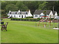
2
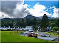
View from the harbour
Looking over Corrie from the harbour towards Goat Fell the highest peak on Arran.
Image: © Andy Farrington
Taken: 28 Jul 2012
0.03 miles
4
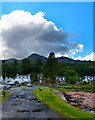
Corrie Harbour
High tide at the harbour with storm clouds on the horizon. The weather on Arran changes at the drop of a hat and next visit I hope to climb Goat Fell centre of picture, but I'll make sure I have my full bag of kit with me for the challenge.
Image: © Andy Farrington
Taken: 28 Jul 2012
0.04 miles
5
Corrie village from the Quay, Isle of Arran
Image: © Becky Williamson
Taken: 10 Jul 2010
0.05 miles
7
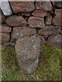
Milestone 52, Corrie, Isle of Arran
Arran's circular road and The String road contain a total of approximately 50 red sandstone milestones, marking, I believe, the miles round the island. There is a book, 'The Milestones of Arran' by Ruth and Alan Thompson, dedicated to them, listing not only the view from each, but also details of flora and fauna to be found at each location.
Some of the milestones were difficult to locate whilst driving in the rain, others were damaged and some appeared to be missing. I have added those that I could safely stop at and those that I could find.
No. 52 is situated next to a sandstone garden wall ('Kennetwell') in Corrie. Parking is easy at the quayside on the other side of the road. Corrie is an attractive village. Flora and fauna seen here included Oystercatcher, Swallow, Rock Pipit, Herring Gull, Broom and Bramble.
Image: © Becky Williamson
Taken: 10 Jul 2010
0.06 miles
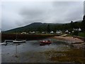
8
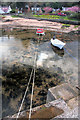
Boats in Sandstone Quay, Corrie
Looking back towards the shore from the harbour arm.
Image: © Bob Jones
Taken: 1 May 2008
0.06 miles
9
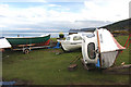
Boat park, Sandstone Quay, Corrie
A grassy area immediately south of the quay serves as a boat park, where craft can be maintained.
Image: © Bob Jones
Taken: 1 May 2008
0.06 miles
10
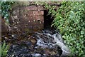
Arran - Corrie - Streams join by harbour
A stream which has flowed under the road meets another stream here, just before flowing into the sea at Image]
Image: © Rob Farrow
Taken: 24 Aug 2024
0.06 miles