IMAGES TAKEN NEAR TO
Shiskine, ISLE OF ARRAN, KA27 8HD
Introduction
This page details the photographs taken nearby to KA27 8HD by members of the Geograph project.
The Geograph project started in 2005 with the aim of publishing, organising and preserving representative images for every square kilometre of Great Britain, Ireland and the Isle of Man.

There are currently over 7.5m images from over14,400 individuals and you can help contribute to the project by visiting https://www.geograph.org.uk
Image Map
Images are licensed for reuse under creativecommons.org/licenses/by-sa/2.0
Notes
- Clicking on the map will re-center to the selected point.
- The higher the marker number, the further away the image location is from the centre of the postcode.
Image Listing (7 Images Found)
Images are licensed for reuse under creativecommons.org/licenses/by-sa/2.0
Image
Details
Distance
2
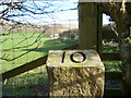
Milestone 10 Arran (String)
Newly painted number
Image: © Brian Robertson
Taken: 5 Mar 2012
0.05 miles
3
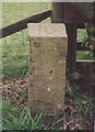
Old Milestone by the B880, North Feoline, Kilmory parish
Arran by the B880, in parish of Kilmory (Arran District), No.1 Torr Righe Terrace, under hedge just before No.1, East side of road.
Inscription reads:-
10
(To Brodick Old Quay)
Surveyed
Milestone Society National ID: AYN_ARRS10
Image: © Milestone Society
Taken: Unknown
0.05 miles