IMAGES TAKEN NEAR TO
Blackwaterfoot, ISLE OF ARRAN, KA27 8HA
Introduction
This page details the photographs taken nearby to KA27 8HA by members of the Geograph project.
The Geograph project started in 2005 with the aim of publishing, organising and preserving representative images for every square kilometre of Great Britain, Ireland and the Isle of Man.

There are currently over 7.5m images from over14,400 individuals and you can help contribute to the project by visiting https://www.geograph.org.uk
Image Map
Images are licensed for reuse under creativecommons.org/licenses/by-sa/2.0
Notes
- Clicking on the map will re-center to the selected point.
- The higher the marker number, the further away the image location is from the centre of the postcode.
Image Listing (105 Images Found)
Images are licensed for reuse under creativecommons.org/licenses/by-sa/2.0
Image
Details
Distance
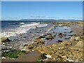
1
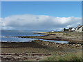
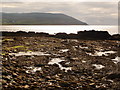
Coastline at Blackwaterfoot
Small harbour on Arran's west coast.
Image: © James Allan
Taken: 5 Oct 2018
0.06 miles
2
Triassic strata with dyke
A basalt dyke (left) intrudes gently-inclined sandstones of Triassic age on the shore. This is a wonderful exposure which highlights the difference in hardness and erosion potential of the two rock types. Rounded boulders of the black-coloured basalt lie all over the beach. They have been eroded from this and other dyke exposures nearby. A particular contrast in the type of intrusive rock, and in the inclination of the Triassic strata when compared with those found to the east. See also Image
Image: © Jonathan Wilkins
Taken: 4 Sep 2022
0.06 miles
3
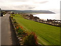
Blackwaterfoot: lawn alongside the shore
A well kept lawn separates the road and the shoreline. Black Head is in the background.
Image: © Chris Downer
Taken: 27 Sep 2010
0.07 miles
4

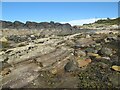
Triassic strata
The foreshore to the west of Blackwaterfoot has fine, tilted outcrops of Triassic sandstone and mudstone which are characteristically red in colour, though this is obscured by barnacles in places. To the right of this image an intrusion of felsite makes a discordant feature.
Image: © Jonathan Wilkins
Taken: 4 Sep 2022
0.08 miles
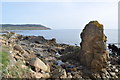
5
Flow Banding in the Felsite
At first one could be forgiven for thinking this light coloured rock could be sandstone. These look like ripple marks, however they are probably flow banding marks. Image]
Image: © Ashley Dace
Taken: 8 Apr 2011
0.08 miles
6
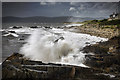
Blackwaterfoot: rock-pools and seaweed
The combination of shallow rock-pools and slippery seaweed make for a hazardous walk along this part of the rocky shoreline.
Brown Head is the headland in the distance.
Image: © Chris Downer
Taken: 27 Sep 2010
0.08 miles
7
Felsite Intrusion
This looks like sandstone at first due to its colour, it even has 'ripple marks'. However why would this block of sandstone survive and the rest not. The answer is solved when looking at a fresh face through a hand lens. Small crystals can be seen. This is in fact a felsite, the same as the QFP in the area but without the phenocrysts. The 'ripple marks' are most likely flow banding remains.
Image: © Ashley Dace
Taken: 8 Apr 2011
0.08 miles
8
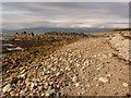
Blackwaterfoot: pebbles, rocks and sandy beach
Looking along the coast at Blackwaterfoot, with substantial rocks separating the pebbly area here from the sandy beach in the distance.
Image: © Chris Downer
Taken: 27 Sep 2010
0.08 miles
9
Blackwaterfoot
Blackwaterfoot on the Isle of Arran.
Image: © James Johnstone
Taken: 11 Jun 2017
0.09 miles
10
Shore with boulders
A view of the shore at low tide, where large, rounded boulders make small islands in the surf. In the foreground, smooth rock outcrop is notably pale in colour and very compact. This is part of a felsic sill intruding softer sandstones which have eroded away and become buried in the beach sand.
Image: © Jonathan Wilkins
Taken: 4 Sep 2022
0.09 miles