IMAGES TAKEN NEAR TO
Red Quarry Road, ISLE OF ARRAN, KA27 8FD
Introduction
This page details the photographs taken nearby to Red Quarry Road, KA27 8FD by members of the Geograph project.
The Geograph project started in 2005 with the aim of publishing, organising and preserving representative images for every square kilometre of Great Britain, Ireland and the Isle of Man.

There are currently over 7.5m images from over14,400 individuals and you can help contribute to the project by visiting https://www.geograph.org.uk
Image Map
Images are licensed for reuse under creativecommons.org/licenses/by-sa/2.0
Notes
- Clicking on the map will re-center to the selected point.
- The higher the marker number, the further away the image location is from the centre of the postcode.
Image Listing (22 Images Found)
Images are licensed for reuse under creativecommons.org/licenses/by-sa/2.0
Image
Details
Distance
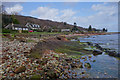
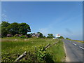
2
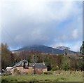
The Steading with Am Binnein behind
The Steading is a small group of holiday lets at Corrie. The 665m (2181') tump of Am Binnein rises in the background swathed in low cloud. Behind and slightly to the right of this is the snow-flecked ridge of (I think) Mullach Buidhe (= yellow summit) (819m)
Image: © Rob Farrow
Taken: 6 Apr 2013
0.06 miles
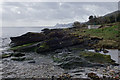
9
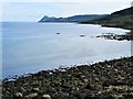
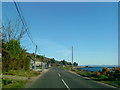
East Coast of Arran
Looking south from a small harbour just south of the small village of Corrie.
Image: © G Laird
Taken: 12 May 2018
0.12 miles