IMAGES TAKEN NEAR TO
Shiskine, ISLE OF ARRAN, KA27 8EN
Introduction
This page details the photographs taken nearby to KA27 8EN by members of the Geograph project.
The Geograph project started in 2005 with the aim of publishing, organising and preserving representative images for every square kilometre of Great Britain, Ireland and the Isle of Man.

There are currently over 7.5m images from over14,400 individuals and you can help contribute to the project by visiting https://www.geograph.org.uk
Image Map
Images are licensed for reuse under creativecommons.org/licenses/by-sa/2.0
Notes
- Clicking on the map will re-center to the selected point.
- The higher the marker number, the further away the image location is from the centre of the postcode.
Image Listing (12 Images Found)
Images are licensed for reuse under creativecommons.org/licenses/by-sa/2.0
Image
Details
Distance
2
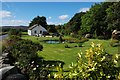
"Sealladhan Dheas" cottage, Bridgend
This attractive cottage and garden lie alongside Clauchan Water. The stone wall to the left of the picture is part of the bridge over the burn and the road is the B880, leading into Shiskine.
Image: © Colin Chambers
Taken: 3 Sep 2007
0.02 miles
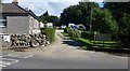
3
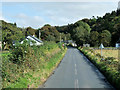
North-east of Shiskine
Scattered houses near Shedog.
Image: © James Allan
Taken: 5 Oct 2018
0.02 miles
4
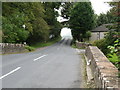
Tree arch and Bridge near Shiskine on the Isle of Arran
Image: © Andy Jamieson
Taken: 12 Sep 2006
0.03 miles
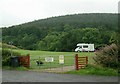
6
Entrance to Bridgend Cottages and camp site
Image: © Gordon Brown
Taken: 24 Aug 2020
0.12 miles

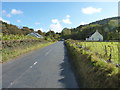
8
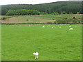
Pasture at Shiskine
With rougher ground and forestry beyond.
Image: © M J Richardson
Taken: 11 May 2011
0.17 miles
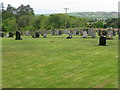
10
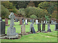
Burial ground near to Shiskine
The term burial ground somehow suggests an old site for burials and perhaps one no longer in use but this one, close to the settlement at Shiskine, is surely currently in use.
Image: © Trevor Littlewood
Taken: 19 Oct 2014
0.17 miles