IMAGES TAKEN NEAR TO
Brodick, ISLE OF ARRAN, KA27 8BJ
Introduction
This page details the photographs taken nearby to KA27 8BJ by members of the Geograph project.
The Geograph project started in 2005 with the aim of publishing, organising and preserving representative images for every square kilometre of Great Britain, Ireland and the Isle of Man.

There are currently over 7.5m images from over14,400 individuals and you can help contribute to the project by visiting https://www.geograph.org.uk
Image Map
Images are licensed for reuse under creativecommons.org/licenses/by-sa/2.0
Notes
- Clicking on the map will re-center to the selected point.
- The higher the marker number, the further away the image location is from the centre of the postcode.
Image Listing (7 Images Found)
Images are licensed for reuse under creativecommons.org/licenses/by-sa/2.0
Image
Details
Distance
1
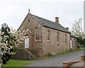
Larchburn - Isle of Arran
Larchburn
Image: © Raibeart MacAoidh
Taken: 26 May 2018
0.04 miles
2
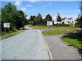
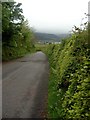
Coming into Brodick
The approach from Lamlash.
Image: © Gordon Brown
Taken: 25 Jun 2009
0.07 miles
3
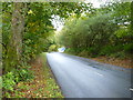
Entering Brodick from Lamlash
On the A841 near Strathwhillan.
Image: © James Allan
Taken: 3 Oct 2018
0.09 miles
4
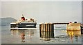
Brodick Pier with Caledonian MacBrayne Ferry
Image: © Christine Matthews
Taken: 10 Jul 1997
0.13 miles
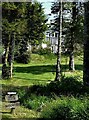
6
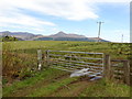
The Corriegills Road
Looking towards Brodick
Image: © Gordon Brown
Taken: 17 May 2007
0.20 miles